Araguari geodata
Araguari (Minas Gerais) is a populated place; located in Brazil in America/Sao_Paulo (GMT-3) time zone. With population of 96,565 people, there are 242 cities with bigger population in this country. Compared to other cities in Brazil, 52.3% of cities are located further ↑North; 65.6% of cities are located further →East and 96.4% of cities have lower elevation than Araguari. Note1


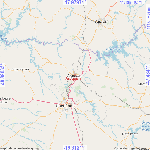
Araguari GPS coordinates[2]
18° 38' 49.992" South, 48° 11' 13.992" West
| Map corner | latitude | longitude |
|---|---|---|
| Upper-left | -17.97971°, | -48.89035° |
| Center: | -18.64722°, | -48.18722° |
| Lower-right: | -19.31211°, | -47.4841° |
| Map W x H: | 148.1×148.2 km | = 92×92.1mi |
| max Lat: | 2.81972° ⇑52.3% North |
| Araguari: | -18.64722° |
| min Lat: | ⇓47.7% South -33.69111° |
| min Long | Araguari | max Long |
| -72.89583° | -48.18722° | -32.41083° |
| W 34.4%⇐ | ⇒65.6% E |
Elevation
Elevation of Araguari is 925 m = 3035 ft, and this is 544.1 m = 1785 ft above average elevation for this country.
| Max E: |
1603 m = 5259 ft | 3.6% |
| Araguari | 925 m 3035 ft | |
| Avg. | 380.9 m = 1250 ft | |
Min E: |
0 m = 0 ft | 96.4% |
See also: Araguari elevation on elevation.city.
Geographical zone
Araguari is located in South Torrid zone (between Equator and Tropic of Capricorn). Distance of this Southern Tropic circle is 532.5 km =330.9 mi to South.| Distance of | km | miles | from Araguari |
|---|---|---|---|
| Equator | 2073.4 | 1288.4 | to North |
| Tropic Capricorn | 532.5 | 330.9 | to South |
| Antarctic Circle | 5327.8 | 3310.5 | to South |
| South Pole | 7933.7 | 4929.8 | to South |


Nearby cities:
15 places around Araguari: (largest is in red/bold)
• Buriti Alegre
106.2 km =66 mi,  302°
302°
• Caldas Novas
110.7 km =68.8 mi,  335°
335°
• Catalão
59.2 km =36.8 mi,  25°
25°
• Centralina
106.9 km =66.4 mi,  273°
273°
• Coromandel
105.8 km =65.7 mi,  79°
79°
• Ipameri
102.9 km =63.9 mi,  1°
1°
• Ituiutaba
139 km =86.4 mi,  254°
254°
• Itumbiara
111.3 km =69.2 mi,  283°
283°
• Monte Alegre de Minas
77.1 km =47.9 mi, 251°
• Monte Carmelo
73 km =45.4 mi,  96°
96°
• Patrocínio
130 km =80.8 mi, 104°
• Prata
106.7 km =66.3 mi,  226°
226°
• Tupaciguara
54.9 km =34.1 mi, 276°
• Uberaba
125.3 km =77.9 mi,  167°
167°
• Uberlândia
31.6 km =19.6 mi,  197°
197°
Sources, notices
• [Note1] Compared only with cities in Brazil existing in our database
• [Src1] Map data: © OpenStreetMap contributors (CC-BY-SA)
• [Src2] Other city data from geonames.org with taken over terms of usage.
• [Src3] Geographical zone / Annual Mean Temperature by Robert A. Rohde @ Wikipedia
