Catalão geodata
Catalão (Goiás) is a populated place; located in Brazil in America/Sao_Paulo (GMT-3) time zone. With population of 63,544 people, there are 352 cities with bigger population in this country. Compared to other cities in Brazil, 51.4% of cities are located further ↑North; 64.3% of cities are located further →East and 92.1% of cities have lower elevation than Catalão. Note1


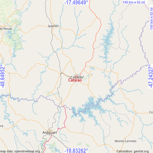
Catalão GPS coordinates[2]
18° 9' 56.988" South, 47° 56' 47.004" West
| Map corner | latitude | longitude |
|---|---|---|
| Upper-left | -17.49649°, | -48.64952° |
| Center: | -18.16583°, | -47.94639° |
| Lower-right: | -18.83262°, | -47.24327° |
| Map W x H: | 148.6×148.6 km | = 92.3×92.3mi |
| max Lat: | 2.81972° ⇑51.4% North |
| Catalão: | -18.16583° |
| min Lat: | ⇓48.6% South -33.69111° |
| min Long | Catalão | max Long |
| -72.89583° | -47.94639° | -32.41083° |
| W 35.7%⇐ | ⇒64.3% E |
Elevation
Elevation of Catalão is 843 m = 2766 ft, and this is 462.1 m = 1516 ft above average elevation for this country.
| Max E: |
1603 m = 5259 ft | 7.9% |
| Catalão | 843 m 2766 ft | |
| Avg. | 380.9 m = 1250 ft | |
Min E: |
0 m = 0 ft | 92.1% |
See also: Catalão elevation on elevation.city.
Geographical zone
Catalão is located in South Torrid zone (between Equator and Tropic of Capricorn). Distance of this Southern Tropic circle is 586.1 km =364.2 mi to South.| Distance of | km | miles | from Catalão |
|---|---|---|---|
| Equator | 2019.9 | 1255.1 | to North |
| Tropic Capricorn | 586.1 | 364.2 | to South |
| Antarctic Circle | 5381.3 | 3343.8 | to South |
| South Pole | 7987.2 | 4963 | to South |


Nearby cities:
15 places around Catalão: (largest is in red/bold)
• Araguari
59.2 km =36.8 mi,  205°
205°
• Buriti Alegre
115.6 km =71.8 mi,  271°
271°
• Caldas Novas
86 km =53.4 mi,  303°
303°
• Coromandel
85.9 km =53.4 mi,  113°
113°
• Ipameri
54.3 km =33.7 mi,  335°
335°
• Itumbiara
136.9 km =85.1 mi,  258°
258°
• Monte Alegre de Minas
125.9 km =78.2 mi,  231°
231°
• Monte Carmelo
78.1 km =48.5 mi,  142°
142°
• Morrinhos
131.2 km =81.5 mi,  291°
291°
• Orizona
131.5 km =81.7 mi, 343°
• Patrocínio
132.6 km =82.4 mi,  130°
130°
• Pires do Rio
102.6 km =63.8 mi, 339°
• Tupaciguara
93 km =57.8 mi,  239°
239°
• Uberlândia
90.7 km =56.4 mi,  202°
202°
• Vazante
111.6 km =69.3 mi,  79°
79°
Sources, notices
• [Note1] Compared only with cities in Brazil existing in our database
• [Src1] Map data: © OpenStreetMap contributors (CC-BY-SA)
• [Src2] Other city data from geonames.org with taken over terms of usage.
• [Src3] Geographical zone / Annual Mean Temperature by Robert A. Rohde @ Wikipedia
