Itinga geodata
Itinga (Minas Gerais) is a populated place; located in Brazil in America/Sao_Paulo (GMT-3) time zone. With population of 4,915 people, there are 1922 cities with bigger population in this country. Compared to other cities in Brazil, 51.8% of cities are located further ↓South; 67% of cities are located further ←West and 55% of cities have higher elevation than Itinga. Note1


Itinga GPS coordinates[2]
16° 36' 47.016" South, 41° 45' 55.008" West
| Map corner | latitude | longitude |
|---|---|---|
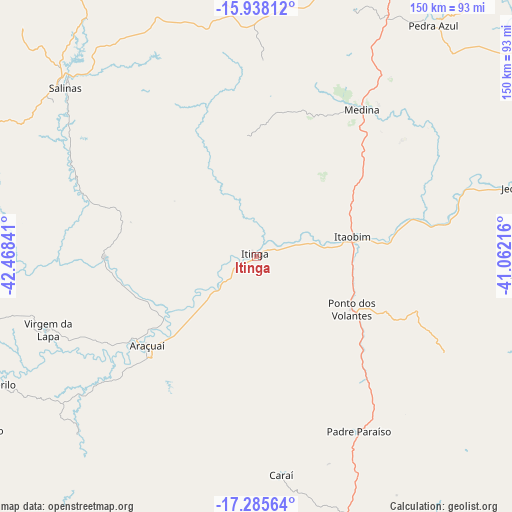
| Upper-left | -15.93812°, | -42.46841° |
| Center: | -16.61306°, | -41.76528° |
| Lower-right: | -17.28564°, | -41.06216° |
| Map W x H: | 149.8×149.8 km | = 93.1×93.1mi |
| max Lat: | 2.81972° ⇑48.2% North |
| Itinga: | -16.61306° |
| min Lat: | ⇓51.8% South -33.69111° |
| min Long | Itinga | max Long |
| -72.89583° | -41.76528° | -32.41083° |
| W 67%⇐ | ⇒33% E |
Elevation
Elevation of Itinga is 268 m = 879 ft, and this is 112.9 m = 370 ft below average elevation for this country.
| Max E: |
1603 m = 5259 ft | 55% |
| Avg. | 380.9 m = 1250 ft | |
| Itinga | 268 m = 879 ft | |
Min E: |
0 m = 0 ft | 45% |
See also: Brazil elevation on elevation.city.
Geographical zone
Itinga is located in South Torrid zone (between Equator and Tropic of Capricorn). Distance of this Southern Tropic circle is 758.7 km =471.4 mi to South.| Distance of | km | miles | from Itinga |
|---|---|---|---|
| Equator | 1847.2 | 1147.8 | to North |
| Tropic Capricorn | 758.7 | 471.4 | to South |
| Antarctic Circle | 5554 | 3451.1 | to South |
| South Pole | 8159.9 | 5070.3 | to South |


Nearby cities:
15 places around Itinga: (largest is in red/bold)
• Almenara
123.8 km =76.9 mi,  67°
67°
• Araçuaí
41.8 km =26 mi,  230°
230°
• Caraí
64.5 km =40.1 mi,  173°
173°
• Jequitinhonha
83.6 km =51.9 mi,  76°
76°
• Joaíma
78.4 km =48.7 mi,  93°
93°
• Medina
53.2 km =33.1 mi,  35°
35°
• Minas Novas
110.6 km =68.7 mi, 232°
• Novo Cruzeiro
95.8 km =59.5 mi,  187°
187°
• Padre Paraíso
59.3 km =36.8 mi,  149°
149°
• Pedra Azul
84 km =52.2 mi, 36°
• Salinas
74.6 km =46.4 mi,  311°
311°
• Taiobeiras
102.5 km =63.7 mi,  330°
330°
• Turmalina
127 km =78.9 mi, 233°
• Águas Formosas
102.5 km =63.7 mi,  120°
120°
• Águas Vermelhas
101.6 km =63.1 mi,  18°
18°
Sources, notices
• [Note1] Compared only with cities in Brazil existing in our database
• [Src1] Map data: © OpenStreetMap contributors (CC-BY-SA)
• [Src2] Other city data from geonames.org with taken over terms of usage.
• [Src3] Geographical zone / Annual Mean Temperature by Robert A. Rohde @ Wikipedia
