Joaíma geodata
Joaíma (Minas Gerais) is a populated place; located in Brazil in America/Sao_Paulo (GMT-3) time zone. With population of 9,020 people, there are 1716 cities with bigger population in this country. Compared to other cities in Brazil, 51.7% of cities are located further ↓South; 70% of cities are located further ←West and 54.9% of cities have higher elevation than Joaíma. Note1


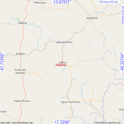
Joaíma GPS coordinates[2]
16° 39' 15.012" South, 41° 1' 50.016" West
| Map corner | latitude | longitude |
|---|---|---|
| Upper-left | -15.97937°, | -41.73369° |
| Center: | -16.65417°, | -41.03056° |
| Lower-right: | -17.3266°, | -40.32744° |
| Map W x H: | 149.8×149.8 km | = 93.1×93.1mi |
| max Lat: | 2.81972° ⇑48.3% North |
| Joaíma: | -16.65417° |
| min Lat: | ⇓51.7% South -33.69111° |
| min Long | Joaíma | max Long |
| -72.89583° | -41.03056° | -32.41083° |
| W 70%⇐ | ⇒30% E |
Elevation
Elevation of Joaíma is 270 m = 886 ft, and this is 110.9 m = 364 ft below average elevation for this country.
| Max E: |
1603 m = 5259 ft | 54.9% |
| Avg. | 380.9 m = 1250 ft | |
| Joaíma | 270 m = 886 ft | |
Min E: |
0 m = 0 ft | 45.1% |
See also: Brazil elevation on elevation.city.
Geographical zone
Joaíma is located in South Torrid zone (between Equator and Tropic of Capricorn). Distance of this Southern Tropic circle is 754.1 km =468.6 mi to South.| Distance of | km | miles | from Joaíma |
|---|---|---|---|
| Equator | 1851.8 | 1150.7 | to North |
| Tropic Capricorn | 754.1 | 468.6 | to South |
| Antarctic Circle | 5549.4 | 3448.2 | to South |
| South Pole | 8155.3 | 5067.5 | to South |


Nearby cities:
15 places around Joaíma: (largest is in red/bold)
• Almenara
63.4 km =39.4 mi,  34°
34°
• Araçuaí
112.8 km =70.1 mi,  258°
258°
• Caraí
92.3 km =57.4 mi,  229°
229°
• Carlos Chagas
120 km =74.6 mi,  166°
166°
• Encruzilhada
125.5 km =78 mi,  5°
5°
• Itanhém
93.8 km =58.3 mi,  127°
127°
• Itinga
78.4 km =48.7 mi,  273°
273°
• Jequitinhonha
24.7 km =15.3 mi, 6°
• Medeiros Neto
117.6 km =73.1 mi, 132°
• Medina
67.6 km =42 mi,  315°
315°
• Novo Cruzeiro
127.5 km =79.2 mi,  224°
224°
• Padre Paraíso
67.2 km =41.8 mi, 225°
• Pedra Azul
77.6 km =48.2 mi,  338°
338°
• Águas Formosas
48.7 km =30.3 mi, 168°
• Águas Vermelhas
110.8 km =68.8 mi, 335°
Sources, notices
• [Note1] Compared only with cities in Brazil existing in our database
• [Src1] Map data: © OpenStreetMap contributors (CC-BY-SA)
• [Src2] Other city data from geonames.org with taken over terms of usage.
• [Src3] Geographical zone / Annual Mean Temperature by Robert A. Rohde @ Wikipedia
