Cacoal geodata
Cacoal (Rondônia) is a populated place; located in Brazil in America/Porto_Velho (GMT-4) time zone. With population of 55,560 people, there are 394 cities with bigger population in this country. Compared to other cities in Brazil, 63.6% of cities are located further ↓South; 97.7% of cities are located further →East and 61.3% of cities have higher elevation than Cacoal. Note1


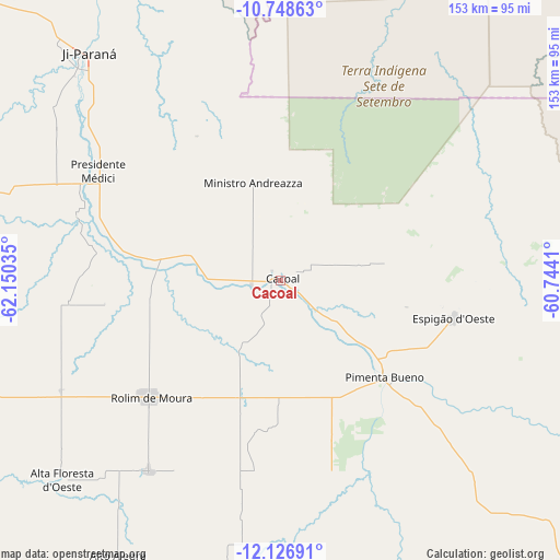
Cacoal GPS coordinates[2]
11° 26' 18.996" South, 61° 26' 49.992" West
| Map corner | latitude | longitude |
|---|---|---|
| Upper-left | -10.74863°, | -62.15035° |
| Center: | -11.43861°, | -61.44722° |
| Lower-right: | -12.12691°, | -60.7441° |
| Map W x H: | 153.3×153.3 km | = 95.3×95.3mi |
| max Lat: | 2.81972° ⇑36.4% North |
| Cacoal: | -11.43861° |
| min Lat: | ⇓63.6% South -33.69111° |
| min Long | Cacoal | max Long |
| -72.89583° | -61.44722° | -32.41083° |
| W 2.3%⇐ | ⇒97.7% E |
Elevation
Elevation of Cacoal is 197 m = 646 ft, and this is 183.9 m = 603 ft below average elevation for this country.
| Max E: |
1603 m = 5259 ft | 61.3% |
| Avg. | 380.9 m = 1250 ft | |
| Cacoal | 197 m = 646 ft | |
Min E: |
0 m = 0 ft | 38.7% |
See also: Cacoal elevation on elevation.city.
Geographical zone
Cacoal is located in South Torrid zone (between Equator and Tropic of Capricorn). Distance of Equator is 1271.9 km =790.3 mi to North.| Distance of | km | miles | from Cacoal |
|---|---|---|---|
| Equator | 1271.9 | 790.3 | to North |
| Tropic Capricorn | 1334.1 | 829 | to South |
| Antarctic Circle | 6129.3 | 3808.6 | to South |
| South Pole | 8735.2 | 5427.8 | to South |


Nearby cities:
11 places around Cacoal: (largest is in red/bold)
• Aripuanã
267.8 km =166.4 mi,  19°
19°
• Ariquemes
243.1 km =151.1 mi,  314°
314°
• Guajará Mirim
430.4 km =267.4 mi,  279°
279°
• Jaru
157.3 km =97.7 mi, 314°
• Ji Paraná
82.5 km =51.3 mi,  318°
318°
• Ouro Preto do Oeste
113.7 km =70.6 mi, 312°
• Pimenta Bueno
37.9 km =23.5 mi,  133°
133°
• Porto Velho
401.1 km =249.2 mi, 317°
• Presidente Médici
57.5 km =35.7 mi,  300°
300°
• Pôsto Fiscal Rolim de Moura
203.8 km =126.6 mi,  206°
206°
• Vilhena
202.4 km =125.8 mi,  135°
135°
Sources, notices
• [Note1] Compared only with cities in Brazil existing in our database
• [Src1] Map data: © OpenStreetMap contributors (CC-BY-SA)
• [Src2] Other city data from geonames.org with taken over terms of usage.
• [Src3] Geographical zone / Annual Mean Temperature by Robert A. Rohde @ Wikipedia
