Cockburn Town geodata
Cockburn Town (San Salvador) is a seat of a first-order administrative division; located in Bahamas in America/Nassau (GMT-4) time zone. With population of 831 people, there are 15 cities with bigger population in this country. Compared to other cities in Bahamas, 66.7% of cities are located further ↑North; 83.3% of cities are located further ←West and 66.7% of cities have lower elevation than Cockburn Town. Note1


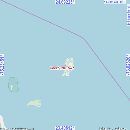
Cockburn Town GPS coordinates[2]
24° 3' 6.444" North, 74° 31' 52.968" West
| Map corner | latitude | longitude |
|---|---|---|
| Upper-left | 24.69225°, | -75.23451° |
| Center: | 24.05179°, | -74.53138° |
| Lower-right: | 23.40812°, | -73.82826° |
| Map W x H: | 142.8×142.8 km | = 88.7×88.7mi |
| max Lat: | 26.87137° ⇑66.7% North |
| Cockburn Town: | 24.05179° |
| min Lat: | ⇓33.3% South 20.94982° |
| min Long | Cockburn Town | max Long |
| -79.29721° | -74.53138° | -72.96667° |
| W 83.3%⇐ | ⇒16.7% E |
Elevation
Elevation of Cockburn Town is 10 m = 33 ft, and this is 0.5 m = 2 ft above average elevation for this country.
| Max E: |
27 m = 89 ft | 33.3% |
| Cockburn Town | 10 m 33 ft | |
| Avg. | 9.5 m = 31 ft | |
Min E: |
1 m = 3 ft | 66.7% |
See also: Bahamas elevation on elevation.city.
Geographical zone
Cockburn Town is located in North temperate zone (between Tropic of Cancer and the Arctic Circle). Distance of this Northern Tropic circle is 68.4 km =42.5 mi to South.| Distance of | km | miles | from Cockburn Town |
|---|---|---|---|
| North Pole | 7332.8 | 4556.4 | to North |
| Arctic Circle | 4726.9 | 2937.2 | to North |
| Tropic Cancer | 68.4 | 42.5 | to South |
| Equator | 2674.3 | 1661.7 | to South |


Nearby cities:
15 places around Cockburn Town: (largest is in red/bold)
• Abraham’s Bay
246.3 km =153 mi,  139°
139°
• Andros Town
335.8 km =208.7 mi,  282°
282°
• Arthur’s Town
131.8 km =81.9 mi,  298°
298°
• Black Point
188.1 km =116.9 mi,  271°
271°
• Clarence Town
115.4 km =71.7 mi,  203°
203°
• Colonel Hill
148.1 km =92 mi,  166°
166°
• Duncan Town
240.3 km =149.3 mi,  210°
210°
• Dunmore Town
266.8 km =165.8 mi,  307°
307°
• George Town
140.9 km =87.6 mi,  244°
244°
• Governor’s Harbour
212.1 km =131.8 mi, 305°
• Masons Bay
180.5 km =112.2 mi,  158°
158°
• Matthew Town
356 km =221.2 mi, 165°
• Nassau
305.6 km =189.9 mi,  291°
291°
• Port Nelson
54.7 km =34 mi,  215°
215°
• Spanish Wells
280 km =174 mi, 306°
Sources, notices
• [Note1] Compared only with cities in Bahamas existing in our database
• [Src1] Map data: © OpenStreetMap contributors (CC-BY-SA)
• [Src2] Other city data from geonames.org with taken over terms of usage.
• [Src3] Geographical zone / Annual Mean Temperature by Robert A. Rohde @ Wikipedia
