Dutlwe geodata
Dutlwe (Kweneng) is a populated place; located in Botswana in Africa/Gaborone (GMT+2) time zone. With population of 1,126 people, there are 80 cities with bigger population in this country. Compared to other cities in Botswana, 61.9% of cities are located further ↑North; 80% of cities are located further →East and 77.1% of cities have lower elevation than Dutlwe. Note1


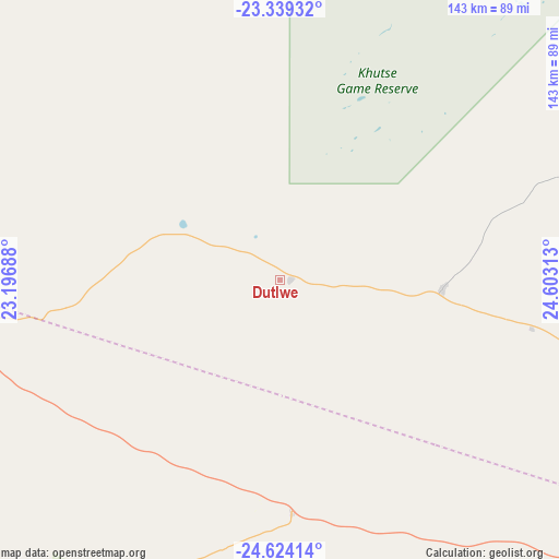
Dutlwe GPS coordinates[2]
23° 58' 59.988" South, 23° 54' 0" East
| Map corner | latitude | longitude |
|---|---|---|
| Upper-left | -23.33932°, | 23.19688° |
| Center: | -23.98333°, | 23.9° |
| Lower-right: | -24.62414°, | 24.60313° |
| Map W x H: | 142.9×142.9 km | = 88.8×88.8mi |
| max Lat: | -17.80165° ⇑61.9% North |
| Dutlwe: | -23.98333° |
| min Lat: | ⇓38.1% South -26.9° |
| min Long | Dutlwe | max Long |
| 20.06667° | 23.9° | 28.74946° |
| W 20%⇐ | ⇒80% E |
Elevation
Elevation of Dutlwe is 1109 m = 3638 ft, and this is 94 m = 308 ft above average elevation for this country.
| Max E: |
1406 m = 4613 ft | 22.9% |
| Dutlwe | 1109 m 3638 ft | |
| Avg. | 1015 m = 3330 ft | |
Min E: |
676 m = 2218 ft | 77.1% |
See also: Botswana elevation on elevation.city.
Geographical zone
Dutlwe is located in South temperate zone (between Tropic of Capricorn and the Antarctic Circle). Distance of this Southern Tropic circle is 60.8 km =37.8 mi to North.| Distance of | km | miles | from Dutlwe |
|---|---|---|---|
| Equator | 2666.7 | 1657 | to North |
| Tropic Capricorn | 60.8 | 37.8 | to North |
| Antarctic Circle | 4734.5 | 2941.9 | to South |
| South Pole | 7340.4 | 4561.1 | to South |


Nearby cities:
15 places around Dutlwe: (largest is in red/bold)
• Boatlaname
201.3 km =125.1 mi,  77°
77°
• Botlhapatlou
161.5 km =100.4 mi,  91°
91°
• Galekgatshwane
202.3 km =125.7 mi,  107°
107°
• Jwaneng
108.5 km =67.4 mi,  129°
129°
• Kang
118.2 km =73.4 mi,  286°
286°
• Kanye
181.6 km =112.8 mi, 127°
• Khakhea
88.6 km =55.1 mi,  207°
207°
• Khudumelapye
87.1 km =54.1 mi, 82°
• Letlhakeng
115.4 km =71.7 mi,  96°
96°
• Molepolole
168.5 km =104.7 mi, 106°
• Mononyane
199.6 km =124 mi, 108°
• Mosopa
177.3 km =110.2 mi,  119°
119°
• Sekoma
46.4 km =28.8 mi,  182°
182°
• Thamaga
182.8 km =113.6 mi, 114°
• Werda
155.7 km =96.7 mi,  203°
203°
Sources, notices
• [Note1] Compared only with cities in Botswana existing in our database
• [Src1] Map data: © OpenStreetMap contributors (CC-BY-SA)
• [Src2] Other city data from geonames.org with taken over terms of usage.
• [Src3] Geographical zone / Annual Mean Temperature by Robert A. Rohde @ Wikipedia
