Sekoma geodata
Sekoma (Ngwaketsi) is a populated place; located in Botswana in Africa/Gaborone (GMT+2) time zone. With population of 1,083 people, there are 81 cities with bigger population in this country. Compared to other cities in Botswana, 68.6% of cities are located further ↑North; 81% of cities are located further →East and 73.3% of cities have lower elevation than Sekoma. Note1


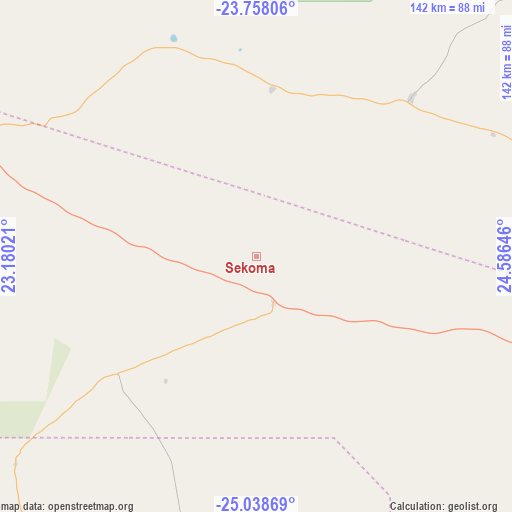
Sekoma GPS coordinates[2]
24° 24' 0" South, 23° 52' 59.988" East
| Map corner | latitude | longitude |
|---|---|---|
| Upper-left | -23.75806°, | 23.18021° |
| Center: | -24.4°, | 23.88333° |
| Lower-right: | -25.03869°, | 24.58646° |
| Map W x H: | 142.4×142.4 km | = 88.5×88.5mi |
| max Lat: | -17.80165° ⇑68.6% North |
| Sekoma: | -24.4° |
| min Lat: | ⇓31.4% South -26.9° |
| min Long | Sekoma | max Long |
| 20.06667° | 23.88333° | 28.74946° |
| W 19%⇐ | ⇒81% E |
Elevation
Elevation of Sekoma is 1096 m = 3596 ft, and this is 81 m = 266 ft above average elevation for this country.
| Max E: |
1406 m = 4613 ft | 26.7% |
| Sekoma | 1096 m 3596 ft | |
| Avg. | 1015 m = 3330 ft | |
Min E: |
676 m = 2218 ft | 73.3% |
See also: Botswana elevation on elevation.city.
Geographical zone
Sekoma is located in South temperate zone (between Tropic of Capricorn and the Antarctic Circle). Distance of this Southern Tropic circle is 107.1 km =66.5 mi to North.| Distance of | km | miles | from Sekoma |
|---|---|---|---|
| Equator | 2713 | 1685.8 | to North |
| Tropic Capricorn | 107.1 | 66.5 | to North |
| Antarctic Circle | 4688.1 | 2913 | to South |
| South Pole | 7294 | 4532.3 | to South |


Nearby cities:
15 places around Sekoma: (largest is in red/bold)
• Botlhapatlou
168.1 km =104.5 mi,  75°
75°
• Dutlwe
46.4 km =28.8 mi,  2°
2°
• Gabane
194.3 km =120.7 mi,  98°
98°
• Jwaneng
88.4 km =54.9 mi, 104°
• Kang
137.4 km =85.4 mi,  305°
305°
• Kanye
159.4 km =99 mi,  113°
113°
• Khakhea
50.9 km =31.6 mi,  230°
230°
• Khudumelapye
105 km =65.2 mi,  56°
56°
• Letlhakeng
121.1 km =75.2 mi,  73°
73°
• Mabuli
169.9 km =105.6 mi,  154°
154°
• Molepolole
163.2 km =101.4 mi,  90°
90°
• Mononyane
191.7 km =119.1 mi, 94°
• Mosopa
160.9 km =100 mi, 104°
• Thamaga
170.2 km =105.8 mi, 100°
• Werda
113.8 km =70.7 mi,  212°
212°
Sources, notices
• [Note1] Compared only with cities in Botswana existing in our database
• [Src1] Map data: © OpenStreetMap contributors (CC-BY-SA)
• [Src2] Other city data from geonames.org with taken over terms of usage.
• [Src3] Geographical zone / Annual Mean Temperature by Robert A. Rohde @ Wikipedia
