Clinton geodata
Clinton (British Columbia) is a seat of a third-order administrative division; located in Canada in America/Vancouver (GMT-7) time zone. In our database, there are 1177 cities with bigger population. Compared to other cities in Canada, 82.7% of cities are located further ↓South; 90.2% of cities are located further →East and 97.1% of cities have lower elevation than Clinton. Note1
Administrative division(s):
- Level 1: British Columbia
- Level 2: Thompson-Nicola Regional District
- Level 3: Clinton


Clinton GPS coordinates[2]
51° 4' 59.124" North, 121° 35' 9.492" West
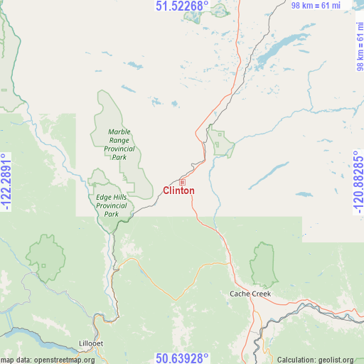
| Map corner | latitude | longitude |
|---|---|---|
| Upper-left | 51.52268°, | -122.2891° |
| Center: | 51.08309°, | -121.58597° |
| Lower-right: | 50.63928°, | -120.88285° |
| Map W x H: | 98.2×98.2 km | = 61×61mi |
| max Lat: | 73.03752° ⇑17.3% North |
| Clinton: | 51.08309° |
| min Lat: | ⇓82.7% South 42.05009° |
| min Long | Clinton | max Long |
| -139.43328° | -121.58597° | -52.70931° |
| W 9.8%⇐ | ⇒90.2% E |
Elevation
Elevation of Clinton is 974 m = 3196 ft, and this is 719.6 m = 2361 ft above average elevation for this country.
| Max E: |
1518 m = 4980 ft | 2.9% |
| Clinton | 974 m 3196 ft | |
| Avg. | 254.4 m = 835 ft | |
Min E: |
-2 m = -7 ft | 97.1% |
See also: Canada elevation on elevation.city.
Geographical zone
Clinton is located in North temperate zone (between Tropic of Cancer and the Arctic Circle). Distance of this North polar circle is 1721.3 km =1069.6 mi to North.| Distance of | km | miles | from Clinton |
|---|---|---|---|
| North Pole | 4327.2 | 2688.8 | to North |
| Arctic Circle | 1721.3 | 1069.6 | to North |
| Tropic Cancer | 3074 | 1910.1 | to South |
| Equator | 5679.9 | 3529.3 | to South |


Nearby cities:
15 places around Clinton: (largest is in red/bold)
• Ashcroft
45.3 km =28.1 mi,  151°
151°
• Barrière
102.9 km =63.9 mi,  83°
83°
• Cache Creek
35.4 km =22 mi, 148°
• Chase
136.4 km =84.8 mi,  102°
102°
• Fox Mountain
123.5 km =76.7 mi,  342°
342°
• Hanceville
137.2 km =85.3 mi,  312°
312°
• Kamloops
100.2 km =62.3 mi,  117°
117°
• Lillooet
50.8 km =31.6 mi,  209°
209°
• Logan Lake
85.1 km =52.9 mi,  139°
139°
• Merritt
121.6 km =75.6 mi, 152°
• Mount Currie 6
113.1 km =70.3 mi,  222°
222°
• Pemberton
120.9 km =75.1 mi,  225°
225°
• Scotch Creek
150.7 km =93.6 mi, 97°
• Whistler
144.3 km =89.7 mi, 221°
• Williams Lake
123.8 km =76.9 mi, 341°
Sources, notices
• [Note1] Compared only with cities in Canada existing in our database
• [Src1] Map data: © OpenStreetMap contributors (CC-BY-SA)
• [Src2] Other city data from geonames.org with taken over terms of usage.
• [Src3] Geographical zone / Annual Mean Temperature by Robert A. Rohde @ Wikipedia
