Bay St. George South geodata
Bay St. George South (Newfoundland and Labrador) is a populated place; located in Canada in America/St_Johns (GMT-2.5) time zone. With population of 1,103 people, there are 1000 cities with bigger population in this country. Compared to other cities in Canada, 55.5% of cities are located further ↓South; 97% of cities are located further ←West and 83.8% of cities have higher elevation than Bay St. George South. Note1


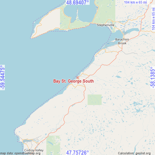
Bay St. George South GPS coordinates[2]
48° 13' 40.116" North, 58° 50' 29.832" West
| Map corner | latitude | longitude |
|---|---|---|
| Upper-left | 48.69407°, | -59.54475° |
| Center: | 48.22781°, | -58.84162° |
| Lower-right: | 47.75726°, | -58.1385° |
| Map W x H: | 104.2×104.2 km | = 64.7×64.7mi |
| max Lat: | 73.03752° ⇑44.5% North |
| Bay St. George South: | 48.22781° |
| min Lat: | ⇓55.5% South 42.05009° |
| min Long | Bay St. George | max Long |
| -139.43328° | -58.84162° | -52.70931° |
| W 97%⇐ | ⇒3% E |
Elevation
Elevation of Bay St. George South is 25 m = 82 ft, and this is 229.4 m = 753 ft below average elevation for this country.
| Max E: |
1518 m = 4980 ft | 83.8% |
| Avg. | 254.4 m = 835 ft | |
| Bay St. George South | 25 m = 82 ft | |
Min E: |
-2 m = -7 ft | 16.2% |
See also: Canada elevation on elevation.city.
Geographical zone
Bay St. George South is located in North temperate zone (between Tropic of Cancer and the Arctic Circle). Distance of this North polar circle is 2038.7 km =1266.8 mi to North.| Distance of | km | miles | from Bay St. George South |
|---|---|---|---|
| North Pole | 4644.6 | 2886 | to North |
| Arctic Circle | 2038.7 | 1266.8 | to North |
| Tropic Cancer | 2756.5 | 1712.8 | to South |
| Equator | 5362.4 | 3332 | to South |


Nearby cities:
15 places around Bay St. George South: (largest is in red/bold)
• Botwood
276.1 km =171.6 mi,  68°
68°
• Burgeo
113.9 km =70.8 mi,  126°
126°
• Channel-Port aux Basques
76.1 km =47.3 mi,  196°
196°
• Corner Brook
103.6 km =64.4 mi,  39°
39°
• Deer Lake
147 km =91.3 mi, 44°
• Glace Bay
241 km =149.8 mi, 200°
• Grand Bank
262.3 km =163 mi,  118°
118°
• Grand Falls-Windsor
246.5 km =153.2 mi, 71°
• Harbour Breton
241.7 km =150.2 mi,  110°
110°
• Pasadena
126.7 km =78.7 mi,  46°
46°
• Springdale
247.5 km =153.8 mi,  55°
55°
• Stephenville
40.6 km =25.2 mi,  28°
28°
• Stephenville Crossing
42.8 km =26.6 mi, 45°
• Sydney
253.8 km =157.7 mi, 203°
• Sydney Mines
244.5 km =151.9 mi,  205°
205°
Sources, notices
• [Note1] Compared only with cities in Canada existing in our database
• [Src1] Map data: © OpenStreetMap contributors (CC-BY-SA)
• [Src2] Other city data from geonames.org with taken over terms of usage.
• [Src3] Geographical zone / Annual Mean Temperature by Robert A. Rohde @ Wikipedia
