Corner Brook geodata
Corner Brook (Newfoundland and Labrador) is a populated place; located in Canada in America/St_Johns (GMT-2.5) time zone. With population of 18,693 people, there are 197 cities with bigger population in this country. Compared to other cities in Canada, 61.6% of cities are located further ↓South; 97.3% of cities are located further ←West and 88.3% of cities have higher elevation than Corner Brook. Note1


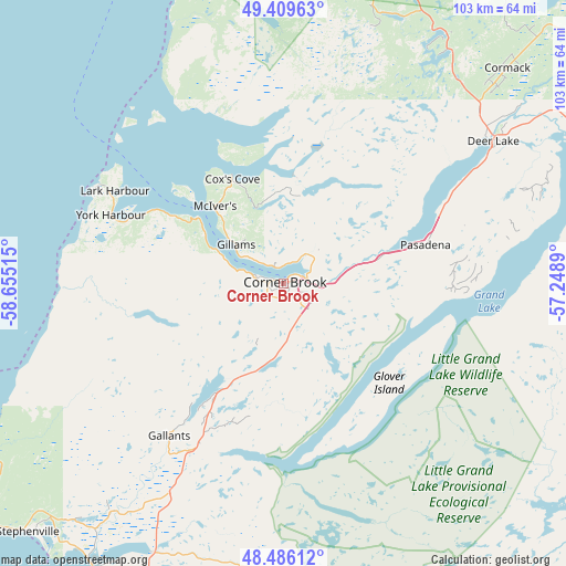
Corner Brook GPS coordinates[2]
48° 57' 0.036" North, 57° 57' 7.272" West
| Map corner | latitude | longitude |
|---|---|---|
| Upper-left | 49.40963°, | -58.65515° |
| Center: | 48.95001°, | -57.95202° |
| Lower-right: | 48.48612°, | -57.2489° |
| Map W x H: | 102.7×102.7 km | = 63.8×63.8mi |
| max Lat: | 73.03752° ⇑38.4% North |
| Corner Brook: | 48.95001° |
| min Lat: | ⇓61.6% South 42.05009° |
| min Long | Corner Brook | max Long |
| -139.43328° | -57.95202° | -52.70931° |
| W 97.3%⇐ | ⇒2.7% E |
Elevation
Elevation of Corner Brook is 17 m = 56 ft, and this is 237.4 m = 779 ft below average elevation for this country.
| Max E: |
1518 m = 4980 ft | 88.3% |
| Avg. | 254.4 m = 835 ft | |
| Corner Brook | 17 m = 56 ft | |
Min E: |
-2 m = -7 ft | 11.7% |
See also: Canada elevation on elevation.city.
Geographical zone
Corner Brook is located in North temperate zone (between Tropic of Cancer and the Arctic Circle). Distance of this North polar circle is 1958.4 km =1216.9 mi to North.| Distance of | km | miles | from Corner Brook |
|---|---|---|---|
| North Pole | 4564.3 | 2836.1 | to North |
| Arctic Circle | 1958.4 | 1216.9 | to North |
| Tropic Cancer | 2836.8 | 1762.7 | to South |
| Equator | 5442.7 | 3381.9 | to South |


Nearby cities:
15 places around Corner Brook: (largest is in red/bold)
• Bay St. George South
103.6 km =64.4 mi,  219°
219°
• Botwood
191 km =118.7 mi,  83°
83°
• Burgeo
150.3 km =93.4 mi,  170°
170°
• Channel-Port aux Basques
176.5 km =109.7 mi,  209°
209°
• Deer Lake
44.9 km =27.9 mi,  57°
57°
• Gander Bay North
256.3 km =159.3 mi, 80°
• Grand Falls-Windsor
167 km =103.8 mi,  90°
90°
• Harbour Breton
228.1 km =141.7 mi,  135°
135°
• La Scie
203.2 km =126.3 mi, 56°
• Lewisporte
214 km =133 mi, 81°
• Pasadena
26.9 km =16.7 mi,  73°
73°
• Springdale
150.1 km =93.3 mi, 65°
• Stephenville
64.1 km =39.8 mi,  226°
226°
• Stephenville Crossing
61.2 km =38 mi, 215°
• Virgin Arm-Carter's Cove
239.1 km =148.6 mi, 74°
Sources, notices
• [Note1] Compared only with cities in Canada existing in our database
• [Src1] Map data: © OpenStreetMap contributors (CC-BY-SA)
• [Src2] Other city data from geonames.org with taken over terms of usage.
• [Src3] Geographical zone / Annual Mean Temperature by Robert A. Rohde @ Wikipedia
