Pasadena geodata
Pasadena (Newfoundland and Labrador) is a populated place; located in Canada in America/St_Johns (GMT-2.5) time zone. With population of 2,248 people, there are 708 cities with bigger population in this country. Compared to other cities in Canada, 62% of cities are located further ↓South; 97.5% of cities are located further ←West and 82.2% of cities have higher elevation than Pasadena. Note1


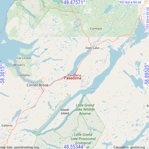
Pasadena GPS coordinates[2]
49° 1' 0.156" North, 57° 35' 54.132" West
| Map corner | latitude | longitude |
|---|---|---|
| Upper-left | 49.47571°, | -58.3015° |
| Center: | 49.01671°, | -57.59837° |
| Lower-right: | 48.55344°, | -56.89525° |
| Map W x H: | 102.5×102.5 km | = 63.7×63.7mi |
| max Lat: | 73.03752° ⇑38% North |
| Pasadena: | 49.01671° |
| min Lat: | ⇓62% South 42.05009° |
| min Long | Pasadena | max Long |
| -139.43328° | -57.59837° | -52.70931° |
| W 97.5%⇐ | ⇒2.5% E |
Elevation
Elevation of Pasadena is 28 m = 92 ft, and this is 226.4 m = 743 ft below average elevation for this country.
| Max E: |
1518 m = 4980 ft | 82.2% |
| Avg. | 254.4 m = 835 ft | |
| Pasadena | 28 m = 92 ft | |
Min E: |
-2 m = -7 ft | 17.8% |
See also: Canada elevation on elevation.city.
Geographical zone
Pasadena is located in North temperate zone (between Tropic of Cancer and the Arctic Circle). Distance of this North polar circle is 1951 km =1212.3 mi to North.| Distance of | km | miles | from Pasadena |
|---|---|---|---|
| North Pole | 4556.9 | 2831.5 | to North |
| Arctic Circle | 1951 | 1212.3 | to North |
| Tropic Cancer | 2844.2 | 1767.3 | to South |
| Equator | 5450.1 | 3386.5 | to South |


Nearby cities:
15 places around Pasadena: (largest is in red/bold)
• Bay St. George South
126.7 km =78.7 mi,  226°
226°
• Botwood
164.5 km =102.2 mi,  84°
84°
• Burgeo
155.7 km =96.7 mi,  180°
180°
• Channel-Port aux Basques
196.8 km =122.3 mi,  215°
215°
• Corner Brook
26.9 km =16.7 mi,  253°
253°
• Deer Lake
20.6 km =12.8 mi,  36°
36°
• Gander Bay North
229.5 km =142.6 mi, 80°
• Grand Falls-Windsor
141.4 km =87.9 mi,  93°
93°
• Harbour Breton
216.4 km =134.5 mi,  141°
141°
• La Scie
177.9 km =110.5 mi,  54°
54°
• Lewisporte
187.3 km =116.4 mi, 82°
• Springdale
123.6 km =76.8 mi,  64°
64°
• Stephenville
88.8 km =55.2 mi, 234°
• Stephenville Crossing
83.9 km =52.1 mi, 226°
• Virgin Arm-Carter's Cove
212.3 km =131.9 mi,  74°
74°
Sources, notices
• [Note1] Compared only with cities in Canada existing in our database
• [Src1] Map data: © OpenStreetMap contributors (CC-BY-SA)
• [Src2] Other city data from geonames.org with taken over terms of usage.
• [Src3] Geographical zone / Annual Mean Temperature by Robert A. Rohde @ Wikipedia
