Lillooet geodata
Lillooet (British Columbia) is a populated place; located in Canada in America/Vancouver (GMT-7) time zone. With population of 2,324 people, there are 699 cities with bigger population in this country. Compared to other cities in Canada, 80.6% of cities are located further ↓South; 90.7% of cities are located further →East and 67.8% of cities have lower elevation than Lillooet. Note1
Administrative division(s):
- Level 1: British Columbia
- Level 2: Squamish-Lillooet Regional District
- Level 3: Lillooet


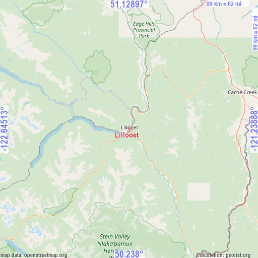
Lillooet GPS coordinates[2]
50° 41' 8.16" North, 121° 56' 31.2" West
| Map corner | latitude | longitude |
|---|---|---|
| Upper-left | 51.12897°, | -122.64513° |
| Center: | 50.6856°, | -121.942° |
| Lower-right: | 50.238°, | -121.23888° |
| Map W x H: | 99.1×99.1 km | = 61.6×61.6mi |
| max Lat: | 73.03752° ⇑19.4% North |
| Lillooet: | 50.6856° |
| min Lat: | ⇓80.6% South 42.05009° |
| min Long | Lillooet | max Long |
| -139.43328° | -121.942° | -52.70931° |
| W 9.3%⇐ | ⇒90.7% E |
Elevation
Elevation of Lillooet is 276 m = 906 ft, and this is 21.6 m = 71 ft above average elevation for this country.
| Max E: |
1518 m = 4980 ft | 32.2% |
| Lillooet | 276 m 906 ft | |
| Avg. | 254.4 m = 835 ft | |
Min E: |
-2 m = -7 ft | 67.8% |
See also: Canada elevation on elevation.city.
Geographical zone
Lillooet is located in North temperate zone (between Tropic of Cancer and the Arctic Circle). Distance of this North polar circle is 1765.5 km =1097 mi to North.| Distance of | km | miles | from Lillooet |
|---|---|---|---|
| North Pole | 4371.4 | 2716.3 | to North |
| Arctic Circle | 1765.5 | 1097 | to North |
| Tropic Cancer | 3029.8 | 1882.6 | to South |
| Equator | 5635.7 | 3501.9 | to South |


Nearby cities:
15 places around Lillooet: (largest is in red/bold)
• Agassiz
162 km =100.7 mi,  175°
175°
• Ashcroft
46.7 km =29 mi,  84°
84°
• Barrière
139.2 km =86.5 mi,  66°
66°
• Cache Creek
45.6 km =28.3 mi, 72°
• Chase
159.4 km =99 mi, 84°
• Clinton
50.8 km =31.6 mi,  29°
29°
• Hanceville
157.1 km =97.6 mi,  330°
330°
• Hope
149.2 km =92.7 mi,  166°
166°
• Kamloops
114.4 km =71.1 mi,  91°
91°
• Logan Lake
83 km =51.6 mi,  104°
104°
• Merritt
103.4 km =64.2 mi,  128°
128°
• Mount Currie 6
64.6 km =40.1 mi,  232°
232°
• Pemberton
73.4 km =45.6 mi,  236°
236°
• Squamish
139.6 km =86.7 mi,  218°
218°
• Whistler
95.5 km =59.3 mi, 228°
Sources, notices
• [Note1] Compared only with cities in Canada existing in our database
• [Src1] Map data: © OpenStreetMap contributors (CC-BY-SA)
• [Src2] Other city data from geonames.org with taken over terms of usage.
• [Src3] Geographical zone / Annual Mean Temperature by Robert A. Rohde @ Wikipedia
