Marystown geodata
Marystown (Newfoundland and Labrador) is a populated place; located in Canada in America/St_Johns (GMT-2.5) time zone. With population of 2,697 people, there are 650 cities with bigger population in this country. Compared to other cities in Canada, 51.1% of cities are located further ↑North; 98.2% of cities are located further ←West and 88.3% of cities have higher elevation than Marystown. Note1


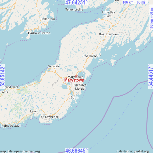
Marystown GPS coordinates[2]
47° 9' 59.868" North, 55° 8' 53.844" West
| Map corner | latitude | longitude |
|---|---|---|
| Upper-left | 47.64251°, | -55.85142° |
| Center: | 47.16663°, | -55.14829° |
| Lower-right: | 46.68645°, | -54.44517° |
| Map W x H: | 106.3×106.3 km | = 66.1×66.1mi |
| max Lat: | 73.03752° ⇑51.1% North |
| Marystown: | 47.16663° |
| min Lat: | ⇓48.9% South 42.05009° |
| min Long | Marystown | max Long |
| -139.43328° | -55.14829° | -52.70931° |
| W 98.2%⇐ | ⇒1.8% E |
Elevation
Elevation of Marystown is 17 m = 56 ft, and this is 237.4 m = 779 ft below average elevation for this country.
| Max E: |
1518 m = 4980 ft | 88.3% |
| Avg. | 254.4 m = 835 ft | |
| Marystown | 17 m = 56 ft | |
Min E: |
-2 m = -7 ft | 11.7% |
See also: Canada elevation on elevation.city.
Geographical zone
Marystown is located in North temperate zone (between Tropic of Cancer and the Arctic Circle). Distance of this North polar circle is 2156.7 km =1340.1 mi to North.| Distance of | km | miles | from Marystown |
|---|---|---|---|
| North Pole | 4762.6 | 2959.3 | to North |
| Arctic Circle | 2156.7 | 1340.1 | to North |
| Tropic Cancer | 2638.5 | 1639.5 | to South |
| Equator | 5244.4 | 3258.7 | to South |


Nearby cities:
15 places around Marystown: (largest is in red/bold)
• Bay Roberts
149.8 km =93.1 mi,  71°
71°
• Blaketown
124.4 km =77.3 mi, 73°
• Bloomfield
164.4 km =102.2 mi,  34°
34°
• Carbonear
158.4 km =98.4 mi, 66°
• Clarenville-Shoal Harbour
143.2 km =89 mi,  38°
38°
• Conception Bay South
166.2 km =103.3 mi,  77°
77°
• Goulds
181.7 km =112.9 mi, 79°
• Grand Bank
47.2 km =29.3 mi,  260°
260°
• Green's Harbour
134.6 km =83.6 mi, 67°
• Harbour Breton
60.3 km =37.5 mi,  305°
305°
• Mount Pearl
182.5 km =113.4 mi, 77°
• St. John's
188.9 km =117.4 mi, 76°
• Torbay
190.1 km =118.1 mi, 73°
• Upper Island Cove
155.1 km =96.4 mi, 69°
• Wabana
173.5 km =107.8 mi, 72°
Sources, notices
• [Note1] Compared only with cities in Canada existing in our database
• [Src1] Map data: © OpenStreetMap contributors (CC-BY-SA)
• [Src2] Other city data from geonames.org with taken over terms of usage.
• [Src3] Geographical zone / Annual Mean Temperature by Robert A. Rohde @ Wikipedia
