Creston geodata
Creston (British Columbia) is a populated place; located in Canada in America/Creston (GMT-7) time zone. With population of 4,816 people, there are 483 cities with bigger population in this country. Compared to other cities in Canada, 63.3% of cities are located further ↓South; 84.4% of cities are located further →East and 88.7% of cities have lower elevation than Creston. Note1
Administrative division(s):
- Level 1: British Columbia
- Level 2: Regional District of Central Kootenay
- Level 3: Creston


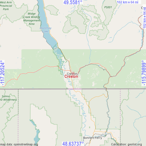
Creston GPS coordinates[2]
49° 5' 59.532" North, 116° 30' 7.596" West
| Map corner | latitude | longitude |
|---|---|---|
| Upper-left | 49.5581°, | -117.20524° |
| Center: | 49.09987°, | -116.50211° |
| Lower-right: | 48.63737°, | -115.79899° |
| Map W x H: | 102.4×102.4 km | = 63.6×63.6mi |
| max Lat: | 73.03752° ⇑36.7% North |
| Creston: | 49.09987° |
| min Lat: | ⇓63.3% South 42.05009° |
| min Long | Creston | max Long |
| -139.43328° | -116.50211° | -52.70931° |
| W 15.6%⇐ | ⇒84.4% E |
Elevation
Elevation of Creston is 647 m = 2123 ft, and this is 392.6 m = 1288 ft above average elevation for this country.
| Max E: |
1518 m = 4980 ft | 11.3% |
| Creston | 647 m 2123 ft | |
| Avg. | 254.4 m = 835 ft | |
Min E: |
-2 m = -7 ft | 88.7% |
See also: Canada elevation on elevation.city.
Geographical zone
Creston is located in North temperate zone (between Tropic of Cancer and the Arctic Circle). Distance of this North polar circle is 1941.8 km =1206.6 mi to North.| Distance of | km | miles | from Creston |
|---|---|---|---|
| North Pole | 4547.7 | 2825.8 | to North |
| Arctic Circle | 1941.8 | 1206.6 | to North |
| Tropic Cancer | 2853.5 | 1773.1 | to South |
| Equator | 5459.4 | 3392.3 | to South |


Nearby cities:
15 places around Creston: (largest is in red/bold)
• Castlegar
87.6 km =54.4 mi,  286°
286°
• Cranbrook
69.3 km =43.1 mi,  50°
50°
• Elkford
157.3 km =97.7 mi, 47°
• Fernie
113 km =70.2 mi,  66°
66°
• Fruitvale
76.5 km =47.5 mi,  271°
271°
• Grand Forks
141 km =87.6 mi, 266°
• Jaffray
92.6 km =57.5 mi, 70°
• Kimberley
74 km =46 mi,  30°
30°
• Nelson
72.1 km =44.8 mi,  308°
308°
• Rossland
94.7 km =58.8 mi, 268°
• Salmo
56.9 km =35.4 mi,  281°
281°
• Sion
145.3 km =90.3 mi, 266°
• Sparwood
136.5 km =84.8 mi,  58°
58°
• Trail
87.4 km =54.3 mi, 269°
• Wynndel
9.6 km =6 mi,  337°
337°
Sources, notices
• [Note1] Compared only with cities in Canada existing in our database
• [Src1] Map data: © OpenStreetMap contributors (CC-BY-SA)
• [Src2] Other city data from geonames.org with taken over terms of usage.
• [Src3] Geographical zone / Annual Mean Temperature by Robert A. Rohde @ Wikipedia
