London geodata
London (Ontario) is a populated place; located in Canada in America/Toronto (GMT-4) time zone. With population of 346,765 people, there are 17 cities with bigger population in this country. Compared to other cities in Canada, 97.6% of cities are located further ↑North; 59.9% of cities are located further →East and 64.2% of cities have lower elevation than London. Note1


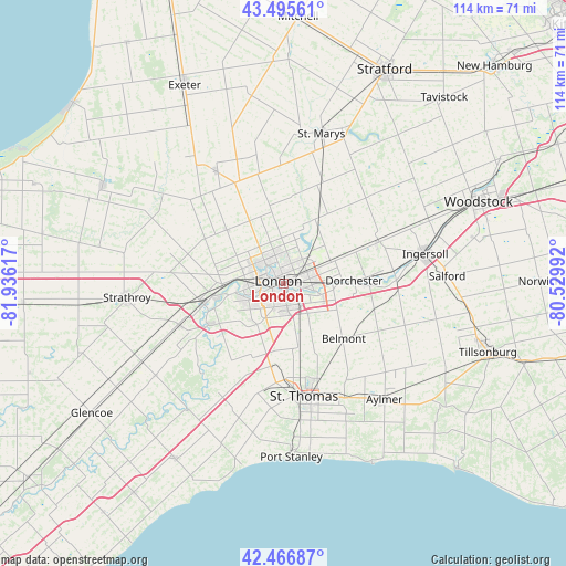
London GPS coordinates[2]
42° 59' 0.204" North, 81° 13' 58.944" West
| Map corner | latitude | longitude |
|---|---|---|
| Upper-left | 43.49561°, | -81.93617° |
| Center: | 42.98339°, | -81.23304° |
| Lower-right: | 42.46687°, | -80.52992° |
| Map W x H: | 114.4×114.4 km | = 71.1×71.1mi |
| max Lat: | 73.03752° ⇑97.6% North |
| London: | 42.98339° |
| min Lat: | ⇓2.4% South 42.05009° |
| min Long | London | max Long |
| -139.43328° | -81.23304° | -52.70931° |
| W 40.1%⇐ | ⇒59.9% E |
Elevation
Elevation of London is 252 m = 827 ft, and this is 2.4 m = 8 ft below average elevation for this country.
| Max E: |
1518 m = 4980 ft | 35.8% |
| Avg. | 254.4 m = 835 ft | |
| London | 252 m = 827 ft | |
Min E: |
-2 m = -7 ft | 64.2% |
See also: London elevation on elevation.city.
Geographical zone
London is located in North temperate zone (between Tropic of Cancer and the Arctic Circle). Distance of this Northern Tropic circle is 2173.4 km =1350.5 mi to South.| Distance of | km | miles | from London |
|---|---|---|---|
| North Pole | 5227.8 | 3248.4 | to North |
| Arctic Circle | 2621.9 | 1629.2 | to North |
| Tropic Cancer | 2173.4 | 1350.5 | to South |
| Equator | 4779.3 | 2969.7 | to South |


Nearby cities:
15 places around London: (largest is in red/bold)
• Aylmer
31.5 km =19.6 mi,  139°
139°
• Belmont
16.5 km =10.3 mi,  132°
132°
• Delaware
16.7 km =10.4 mi,  243°
243°
• Dorchester
13.6 km =8.5 mi,  90°
90°
• Glencoe
47.2 km =29.3 mi, 236°
• Ingersoll
29 km =18 mi,  78°
78°
• Lucan
26 km =16.2 mi,  328°
328°
• Mount Brydges
22.4 km =13.9 mi,  245°
245°
• Parkhill
41.6 km =25.8 mi,  298°
298°
• Port Stanley
35.2 km =21.9 mi,  177°
177°
• South Huron
43.6 km =27.1 mi, 328°
• St. Thomas
23.7 km =14.7 mi,  169°
169°
• Stratford
48.4 km =30.1 mi,  28°
28°
• Tavistock
49.3 km =30.6 mi,  41°
41°
• Woodstock
42.7 km =26.5 mi,  66°
66°
Sources, notices
• [Note1] Compared only with cities in Canada existing in our database
• [Src1] Map data: © OpenStreetMap contributors (CC-BY-SA)
• [Src2] Other city data from geonames.org with taken over terms of usage.
• [Src3] Geographical zone / Annual Mean Temperature by Robert A. Rohde @ Wikipedia
