Parkhill geodata
Parkhill (Ontario) is a populated place; located in Canada in America/Toronto (GMT-4) time zone. With population of 1,737 people, there are 804 cities with bigger population in this country. Compared to other cities in Canada, 96.5% of cities are located further ↑North; 61.4% of cities are located further →East and 56.1% of cities have lower elevation than Parkhill. Note1


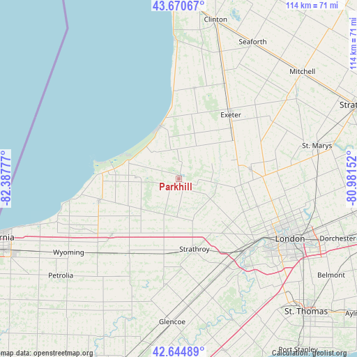
Parkhill GPS coordinates[2]
43° 9' 35.748" North, 81° 41' 4.704" West
| Map corner | latitude | longitude |
|---|---|---|
| Upper-left | 43.67067°, | -82.38777° |
| Center: | 43.15993°, | -81.68464° |
| Lower-right: | 42.64489°, | -80.98152° |
| Map W x H: | 114.1×114.1 km | = 70.9×70.9mi |
| max Lat: | 73.03752° ⇑96.5% North |
| Parkhill: | 43.15993° |
| min Lat: | ⇓3.5% South 42.05009° |
| min Long | Parkhill | max Long |
| -139.43328° | -81.68464° | -52.70931° |
| W 38.6%⇐ | ⇒61.4% E |
Elevation
Elevation of Parkhill is 207 m = 679 ft, and this is 47.4 m = 156 ft below average elevation for this country.
| Max E: |
1518 m = 4980 ft | 43.9% |
| Avg. | 254.4 m = 835 ft | |
| Parkhill | 207 m = 679 ft | |
Min E: |
-2 m = -7 ft | 56.1% |
See also: Canada elevation on elevation.city.
Geographical zone
Parkhill is located in North temperate zone (between Tropic of Cancer and the Arctic Circle). Distance of this Northern Tropic circle is 2193 km =1362.7 mi to South.| Distance of | km | miles | from Parkhill |
|---|---|---|---|
| North Pole | 5208.1 | 3236.2 | to North |
| Arctic Circle | 2602.2 | 1616.9 | to North |
| Tropic Cancer | 2193 | 1362.7 | to South |
| Equator | 4798.9 | 2981.9 | to South |


Nearby cities:
15 places around Parkhill: (largest is in red/bold)
• Belmont
57.8 km =35.9 mi,  122°
122°
• Bluewater
34.8 km =21.6 mi,  11°
11°
• Camlachie
41.1 km =25.5 mi,  250°
250°
• Delaware
34.7 km =21.6 mi,  141°
141°
• Dorchester
53.9 km =33.5 mi,  111°
111°
• Glencoe
45.6 km =28.3 mi,  183°
183°
• Lambton Shores
20.2 km =12.6 mi,  272°
272°
• London
41.6 km =25.8 mi, 118°
• Lucan
23.2 km =14.4 mi,  83°
83°
• Mount Brydges
33.2 km =20.6 mi,  150°
150°
• Petrolia
49.9 km =31 mi,  229°
229°
• Seaforth
49.1 km =30.5 mi,  27°
27°
• South Huron
22.1 km =13.7 mi,  37°
37°
• St. Thomas
59.4 km =36.9 mi, 136°
• Watford
28.4 km =17.6 mi,  214°
214°
Sources, notices
• [Note1] Compared only with cities in Canada existing in our database
• [Src1] Map data: © OpenStreetMap contributors (CC-BY-SA)
• [Src2] Other city data from geonames.org with taken over terms of usage.
• [Src3] Geographical zone / Annual Mean Temperature by Robert A. Rohde @ Wikipedia
