Canora geodata
Canora (Saskatchewan) is a populated place; located in Canada in America/Regina (GMT-6) time zone. With population of 2,055 people, there are 741 cities with bigger population in this country. Compared to other cities in Canada, 84.7% of cities are located further ↓South; 70.2% of cities are located further →East and 81.3% of cities have lower elevation than Canora. Note1


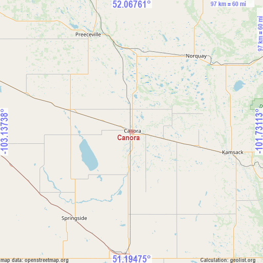
Canora GPS coordinates[2]
51° 37' 59.808" North, 102° 26' 3.3" West
| Map corner | latitude | longitude |
|---|---|---|
| Upper-left | 52.06761°, | -103.13738° |
| Center: | 51.63328°, | -102.43425° |
| Lower-right: | 51.19475°, | -101.73113° |
| Map W x H: | 97.1×97.1 km | = 60.3×60.3mi |
| max Lat: | 73.03752° ⇑15.3% North |
| Canora: | 51.63328° |
| min Lat: | ⇓84.7% South 42.05009° |
| min Long | Canora | max Long |
| -139.43328° | -102.43425° | -52.70931° |
| W 29.8%⇐ | ⇒70.2% E |
Elevation
Elevation of Canora is 489 m = 1604 ft, and this is 234.6 m = 770 ft above average elevation for this country.
| Max E: |
1518 m = 4980 ft | 18.7% |
| Canora | 489 m 1604 ft | |
| Avg. | 254.4 m = 835 ft | |
Min E: |
-2 m = -7 ft | 81.3% |
See also: Canada elevation on elevation.city.
Geographical zone
Canora is located in North temperate zone (between Tropic of Cancer and the Arctic Circle). Distance of this North polar circle is 1660.1 km =1031.5 mi to North.| Distance of | km | miles | from Canora |
|---|---|---|---|
| North Pole | 4266 | 2650.8 | to North |
| Arctic Circle | 1660.1 | 1031.5 | to North |
| Tropic Cancer | 3135.2 | 1948.1 | to South |
| Equator | 5741.1 | 3567.4 | to South |


Nearby cities:
15 places around Canora: (largest is in red/bold)
• Esterhazy
112 km =69.6 mi,  167°
167°
• Foam Lake
75.9 km =47.2 mi,  271°
271°
• Grenfell
139.7 km =86.8 mi,  194°
194°
• Hudson Bay
135.3 km =84.1 mi,  1°
1°
• Indian Head
149.6 km =93 mi,  215°
215°
• Kamsack
37.6 km =23.4 mi,  101°
101°
• Kelvington
96 km =59.7 mi,  308°
308°
• Langenburg
100.4 km =62.4 mi,  150°
150°
• Melville
83.7 km =52 mi,  197°
197°
• Preeceville
38.7 km =24 mi,  335°
335°
• Roblin
87.1 km =54.1 mi,  120°
120°
• Swan River
95.8 km =59.5 mi,  56°
56°
• Wadena
100.4 km =62.4 mi,  290°
290°
• Wynyard
121.5 km =75.5 mi,  277°
277°
• Yorkton
46.4 km =28.8 mi,  182°
182°
Sources, notices
• [Note1] Compared only with cities in Canada existing in our database
• [Src1] Map data: © OpenStreetMap contributors (CC-BY-SA)
• [Src2] Other city data from geonames.org with taken over terms of usage.
• [Src3] Geographical zone / Annual Mean Temperature by Robert A. Rohde @ Wikipedia
