Kamsack geodata
Kamsack (Saskatchewan) is a populated place; located in Canada in America/Regina (GMT-6) time zone. With population of 1,775 people, there are 798 cities with bigger population in this country. Compared to other cities in Canada, 84.5% of cities are located further ↓South; 69.8% of cities are located further →East and 80.1% of cities have lower elevation than Kamsack. Note1


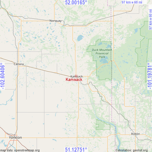
Kamsack GPS coordinates[2]
51° 34' 0.048" North, 101° 54' 3.348" West
| Map corner | latitude | longitude |
|---|---|---|
| Upper-left | 52.00165°, | -102.60406° |
| Center: | 51.56668°, | -101.90093° |
| Lower-right: | 51.12751°, | -101.19781° |
| Map W x H: | 97.2×97.2 km | = 60.4×60.4mi |
| max Lat: | 73.03752° ⇑15.5% North |
| Kamsack: | 51.56668° |
| min Lat: | ⇓84.5% South 42.05009° |
| min Long | Kamsack | max Long |
| -139.43328° | -101.90093° | -52.70931° |
| W 30.2%⇐ | ⇒69.8% E |
Elevation
Elevation of Kamsack is 450 m = 1476 ft, and this is 195.6 m = 642 ft above average elevation for this country.
| Max E: |
1518 m = 4980 ft | 19.9% |
| Kamsack | 450 m 1476 ft | |
| Avg. | 254.4 m = 835 ft | |
Min E: |
-2 m = -7 ft | 80.1% |
See also: Canada elevation on elevation.city.
Geographical zone
Kamsack is located in North temperate zone (between Tropic of Cancer and the Arctic Circle). Distance of this North polar circle is 1667.5 km =1036.1 mi to North.| Distance of | km | miles | from Kamsack |
|---|---|---|---|
| North Pole | 4273.4 | 2655.4 | to North |
| Arctic Circle | 1667.5 | 1036.1 | to North |
| Tropic Cancer | 3127.8 | 1943.5 | to South |
| Equator | 5733.7 | 3562.8 | to South |


Nearby cities:
15 places around Kamsack: (largest is in red/bold)
• Camperville
129.7 km =80.6 mi,  68°
68°
• Canora
37.6 km =23.4 mi,  281°
281°
• Dauphin
136.6 km =84.9 mi,  109°
109°
• Esterhazy
102.7 km =63.8 mi,  187°
187°
• Foam Lake
113.2 km =70.3 mi,  274°
274°
• Grenfell
146.9 km =91.3 mi,  209°
209°
• Hudson Bay
146.4 km =91 mi,  347°
347°
• Kelvington
130.5 km =81.1 mi,  300°
300°
• Langenburg
80.7 km =50.1 mi,  170°
170°
• Melville
95.6 km =59.4 mi,  220°
220°
• Preeceville
67.8 km =42.1 mi,  308°
308°
• Roblin
53.2 km =33.1 mi,  134°
134°
• Swan River
74.1 km =46 mi,  35°
35°
• Wadena
137.5 km =85.4 mi,  288°
288°
• Yorkton
55.3 km =34.4 mi,  225°
225°
Sources, notices
• [Note1] Compared only with cities in Canada existing in our database
• [Src1] Map data: © OpenStreetMap contributors (CC-BY-SA)
• [Src2] Other city data from geonames.org with taken over terms of usage.
• [Src3] Geographical zone / Annual Mean Temperature by Robert A. Rohde @ Wikipedia
