Coalhurst geodata
Coalhurst (Alberta) is a populated place; located in Canada in America/Edmonton (GMT-6) time zone. With population of 1,552 people, there are 849 cities with bigger population in this country. Compared to other cities in Canada, 73.3% of cities are located further ↓South; 77.8% of cities are located further →East and 96.6% of cities have lower elevation than Coalhurst. Note1


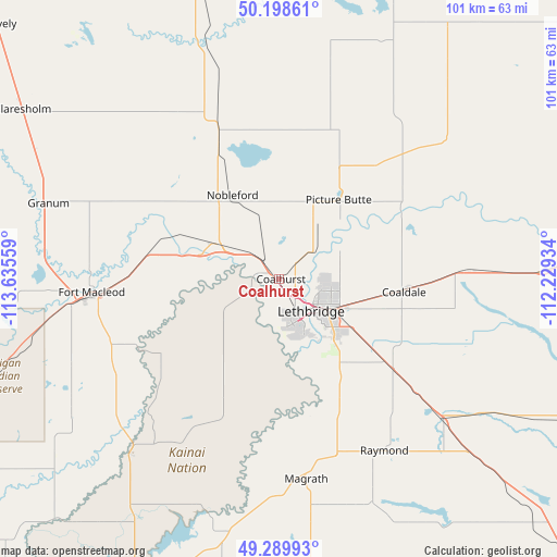
Coalhurst GPS coordinates[2]
49° 44' 47.04" North, 112° 55' 56.856" West
| Map corner | latitude | longitude |
|---|---|---|
| Upper-left | 50.19861°, | -113.63559° |
| Center: | 49.7464°, | -112.93246° |
| Lower-right: | 49.28993°, | -112.22934° |
| Map W x H: | 101×101 km | = 62.8×62.8mi |
| max Lat: | 73.03752° ⇑26.7% North |
| Coalhurst: | 49.7464° |
| min Lat: | ⇓73.3% South 42.05009° |
| min Long | Coalhurst | max Long |
| -139.43328° | -112.93246° | -52.70931° |
| W 22.2%⇐ | ⇒77.8% E |
Elevation
Elevation of Coalhurst is 933 m = 3061 ft, and this is 678.6 m = 2226 ft above average elevation for this country.
| Max E: |
1518 m = 4980 ft | 3.4% |
| Coalhurst | 933 m 3061 ft | |
| Avg. | 254.4 m = 835 ft | |
Min E: |
-2 m = -7 ft | 96.6% |
See also: Canada elevation on elevation.city.
Geographical zone
Coalhurst is located in North temperate zone (between Tropic of Cancer and the Arctic Circle). Distance of this North polar circle is 1869.9 km =1161.9 mi to North.| Distance of | km | miles | from Coalhurst |
|---|---|---|---|
| North Pole | 4475.8 | 2781.1 | to North |
| Arctic Circle | 1869.9 | 1161.9 | to North |
| Tropic Cancer | 2925.4 | 1817.8 | to South |
| Equator | 5531.3 | 3437 | to South |


Nearby cities:
15 places around Coalhurst: (largest is in red/bold)
• Bow Island
113 km =70.2 mi,  83°
83°
• Cardston
66.4 km =41.3 mi,  203°
203°
• Claresholm
56.6 km =35.2 mi,  304°
304°
• Coaldale
22.8 km =14.2 mi,  98°
98°
• Fort Macleod
35.1 km =21.8 mi,  264°
264°
• High River
114.5 km =71.1 mi,  324°
324°
• Lethbridge
9.7 km =6 mi,  122°
122°
• Magrath
36.9 km =22.9 mi,  172°
172°
• Nanton
89.8 km =55.8 mi, 318°
• Picture Butte
18.5 km =11.5 mi,  34°
34°
• Pincher Creek
79.1 km =49.2 mi,  248°
248°
• Raymond
38.7 km =24 mi,  148°
148°
• Taber
56.7 km =35.2 mi,  85°
85°
• Vauxhall
68.3 km =42.4 mi,  58°
58°
• Vulcan
76.2 km =47.3 mi,  342°
342°
Sources, notices
• [Note1] Compared only with cities in Canada existing in our database
• [Src1] Map data: © OpenStreetMap contributors (CC-BY-SA)
• [Src2] Other city data from geonames.org with taken over terms of usage.
• [Src3] Geographical zone / Annual Mean Temperature by Robert A. Rohde @ Wikipedia
