Picture Butte geodata
Picture Butte (Alberta) is a populated place; located in Canada in America/Edmonton (GMT-6) time zone. With population of 1,700 people, there are 812 cities with bigger population in this country. Compared to other cities in Canada, 74.7% of cities are located further ↓South; 77.4% of cities are located further →East and 96% of cities have lower elevation than Picture Butte. Note1


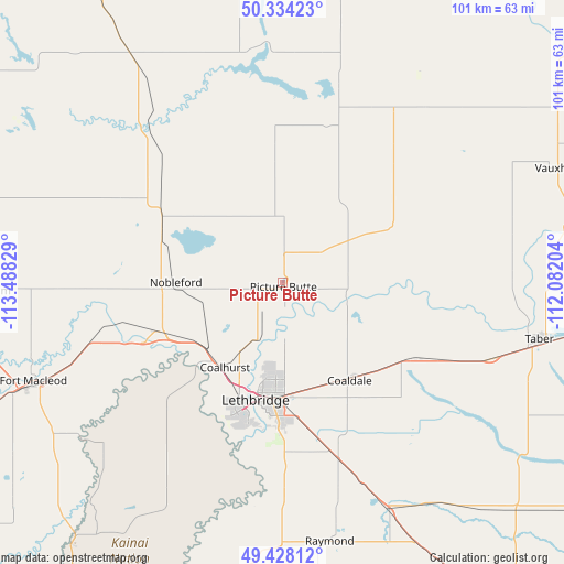
Picture Butte GPS coordinates[2]
49° 52' 59.88" North, 112° 47' 6.576" West
| Map corner | latitude | longitude |
|---|---|---|
| Upper-left | 50.33423°, | -113.48829° |
| Center: | 49.8833°, | -112.78516° |
| Lower-right: | 49.42812°, | -112.08204° |
| Map W x H: | 100.7×100.7 km | = 62.6×62.6mi |
| max Lat: | 73.03752° ⇑25.3% North |
| Picture Butte: | 49.8833° |
| min Lat: | ⇓74.7% South 42.05009° |
| min Long | Picture Butte | max Long |
| -139.43328° | -112.78516° | -52.70931° |
| W 22.6%⇐ | ⇒77.4% E |
Elevation
Elevation of Picture Butte is 906 m = 2972 ft, and this is 651.6 m = 2138 ft above average elevation for this country.
| Max E: |
1518 m = 4980 ft | 4% |
| Picture Butte | 906 m 2972 ft | |
| Avg. | 254.4 m = 835 ft | |
Min E: |
-2 m = -7 ft | 96% |
See also: Canada elevation on elevation.city.
Geographical zone
Picture Butte is located in North temperate zone (between Tropic of Cancer and the Arctic Circle). Distance of this North polar circle is 1854.7 km =1152.5 mi to North.| Distance of | km | miles | from Picture Butte |
|---|---|---|---|
| North Pole | 4460.6 | 2771.7 | to North |
| Arctic Circle | 1854.7 | 1152.5 | to North |
| Tropic Cancer | 2940.6 | 1827.2 | to South |
| Equator | 5546.5 | 3446.4 | to South |


Nearby cities:
15 places around Picture Butte: (largest is in red/bold)
• Bow Island
101.5 km =63.1 mi,  91°
91°
• Brooks
100.8 km =62.6 mi,  39°
39°
• Cardston
84.6 km =52.6 mi,  206°
206°
• Claresholm
59.6 km =37 mi,  286°
286°
• Coaldale
22 km =13.7 mi,  147°
147°
• Coalhurst
18.5 km =11.5 mi, 214°
• Fort Macleod
49.1 km =30.5 mi,  247°
247°
• Lethbridge
20.5 km =12.7 mi,  186°
186°
• Magrath
52.2 km =32.4 mi, 186°
• Nanton
87.2 km =54.2 mi,  306°
306°
• Pincher Creek
95 km =59 mi,  242°
242°
• Raymond
49.1 km =30.5 mi,  168°
168°
• Taber
47.1 km =29.3 mi,  103°
103°
• Vauxhall
51.9 km =32.2 mi,  66°
66°
• Vulcan
66.4 km =41.3 mi,  329°
329°
Sources, notices
• [Note1] Compared only with cities in Canada existing in our database
• [Src1] Map data: © OpenStreetMap contributors (CC-BY-SA)
• [Src2] Other city data from geonames.org with taken over terms of usage.
• [Src3] Geographical zone / Annual Mean Temperature by Robert A. Rohde @ Wikipedia
