Kindu geodata
Kindu (Maniema) is a seat of a first-order administrative division; located in Democratic Republic of the Congo in Africa/Lubumbashi (GMT+2) time zone. With population of 135,698 people, there are 21 cities with bigger population in this country. Compared to other cities in Democratic Republic of the Congo, 57.1% of cities are located further ↓South; 71.4% of cities are located further ←West and 54.3% of cities have higher elevation than Kindu. Note1


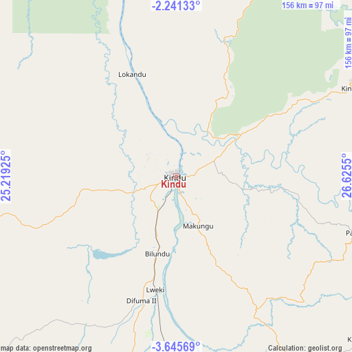
Kindu GPS coordinates[2]
2° 56' 37.428" South, 25° 55' 20.532" East
| Map corner | latitude | longitude |
|---|---|---|
| Upper-left | -2.24133°, | 25.21925° |
| Center: | -2.94373°, | 25.92237° |
| Lower-right: | -3.64569°, | 26.6255° |
| Map W x H: | 156.2×156.2 km | = 97.1×97.1mi |
| max Lat: | 4.279° ⇑42.9% North |
| Kindu: | -2.94373° |
| min Lat: | ⇓57.1% South -11.76097° |
| min Long | Kindu | max Long |
| 12.37148° | 25.92237° | 30.25224° |
| W 71.4%⇐ | ⇒28.6% E |
Elevation
Elevation of Kindu is 464 m = 1522 ft, and this is 192 m = 630 ft below average elevation for this country.
| Max E: |
1996 m = 6549 ft | 54.3% |
| Avg. | 656 m = 2152 ft | |
| Kindu | 464 m = 1522 ft | |
Min E: |
11 m = 36 ft | 45.7% |
See also: Kindu elevation on elevation.city.
Geographical zone
Kindu is located in South Torrid zone (between Equator and Tropic of Capricorn). Distance of Equator is 327.3 km =203.4 mi to North.| Distance of | km | miles | from Kindu |
|---|---|---|---|
| Equator | 327.3 | 203.4 | to North |
| Tropic Capricorn | 2278.6 | 1415.9 | to South |
| Antarctic Circle | 7073.9 | 4395.5 | to South |
| South Pole | 9679.7 | 6014.7 | to South |


Nearby cities:
15 places around Kindu: (largest is in red/bold)
• Bukavu
328.2 km =203.9 mi,  81°
81°
• Goma
393.5 km =244.5 mi,  68°
68°
• Kabalo
362.7 km =225.4 mi,  162°
162°
• Kabare
322.4 km =200.3 mi, 81°
• Kabinda
389.4 km =242 mi,  204°
204°
• Kampene
110 km =68.4 mi,  131°
131°
• Kasongo
184.5 km =114.6 mi,  153°
153°
• Kisangani
393.1 km =244.3 mi,  348°
348°
• Kongolo
296.6 km =184.3 mi, 156°
• Lodja
265.6 km =165 mi,  256°
256°
• Lubao
272.4 km =169.3 mi,  184°
184°
• Lusambo
355.8 km =221.1 mi,  230°
230°
• Mbuji-Mayi
439.1 km =272.8 mi,  216°
216°
• Sake
378.7 km =235.3 mi, 66°
• Uvira
360.5 km =224 mi,  98°
98°
Sources, notices
• [Note1] Compared only with cities in Democratic Republic of the Congo existing in our database
• [Src1] Map data: © OpenStreetMap contributors (CC-BY-SA)
• [Src2] Other city data from geonames.org with taken over terms of usage.
• [Src3] Geographical zone / Annual Mean Temperature by Robert A. Rohde @ Wikipedia
