Kampene geodata
Kampene (Maniema) is a populated place; located in Democratic Republic of the Congo in Africa/Lubumbashi (GMT+2) time zone. With population of 37,034 people, there are 48 cities with bigger population in this country. Compared to other cities in Democratic Republic of the Congo, 50% of cities are located further ↓South; 75.7% of cities are located further ←West and 67.1% of cities have lower elevation than Kampene. Note1


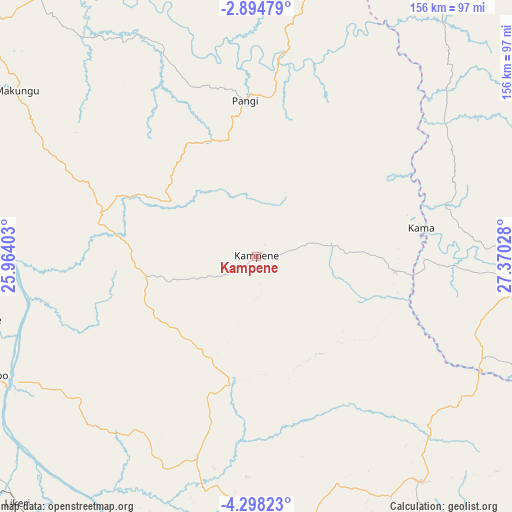
Kampene GPS coordinates[2]
3° 35' 48.408" South, 26° 40' 1.74" East
| Map corner | latitude | longitude |
|---|---|---|
| Upper-left | -2.89479°, | 25.96403° |
| Center: | -3.59678°, | 26.66715° |
| Lower-right: | -4.29823°, | 27.37028° |
| Map W x H: | 156×156.1 km | = 96.9×97mi |
| max Lat: | 4.279° ⇑50% North |
| Kampene: | -3.59678° |
| min Lat: | ⇓50% South -11.76097° |
| min Long | Kampene | max Long |
| 12.37148° | 26.66715° | 30.25224° |
| W 75.7%⇐ | ⇒24.3% E |
Elevation
Elevation of Kampene is 652 m = 2139 ft, and this is 4 m = 13 ft below average elevation for this country.
| Max E: |
1996 m = 6549 ft | 32.9% |
| Avg. | 656 m = 2152 ft | |
| Kampene | 652 m = 2139 ft | |
Min E: |
11 m = 36 ft | 67.1% |
See also: Democratic Republic of the Congo elevation on elevation.city.
Geographical zone
Kampene is located in South Torrid zone (between Equator and Tropic of Capricorn). Distance of Equator is 399.9 km =248.5 mi to North.| Distance of | km | miles | from Kampene |
|---|---|---|---|
| Equator | 399.9 | 248.5 | to North |
| Tropic Capricorn | 2206 | 1370.7 | to South |
| Antarctic Circle | 7001.2 | 4350.3 | to South |
| South Pole | 9607.1 | 5969.6 | to South |


Nearby cities:
15 places around Kampene: (largest is in red/bold)
• Bukavu
271.1 km =168.5 mi,  63°
63°
• Goma
355.9 km =221.1 mi,  53°
53°
• Kabalo
274.4 km =170.5 mi,  174°
174°
• Kabare
265.6 km =165 mi, 62°
• Kabinda
372.1 km =231.2 mi,  220°
220°
• Kalemie
383.1 km =238 mi,  133°
133°
• Kasongo
92.4 km =57.4 mi,  180°
180°
• Kindu
110 km =68.4 mi,  311°
311°
• Kongolo
202.3 km =125.7 mi, 169°
• Lodja
340.4 km =211.5 mi,  271°
271°
• Lubao
223.6 km =138.9 mi,  207°
207°
• Lusambo
388.9 km =241.7 mi,  246°
246°
• Mbuji-Mayi
442.6 km =275 mi,  230°
230°
• Sake
346.8 km =215.5 mi, 49°
• Uvira
275.1 km =170.9 mi,  85°
85°
Sources, notices
• [Note1] Compared only with cities in Democratic Republic of the Congo existing in our database
• [Src1] Map data: © OpenStreetMap contributors (CC-BY-SA)
• [Src2] Other city data from geonames.org with taken over terms of usage.
• [Src3] Geographical zone / Annual Mean Temperature by Robert A. Rohde @ Wikipedia
