Zeglingen geodata
Zeglingen (Basel-Landschaft) is a populated place; located in Switzerland in Europe/Zurich (GMT+2) time zone. With population of 526 people, there are 1769 cities with bigger population in this country. Compared to other cities in Switzerland, 77.1% of cities are located further ↓South; 62.2% of cities are located further →East and 63.6% of cities have lower elevation than Zeglingen. Note1


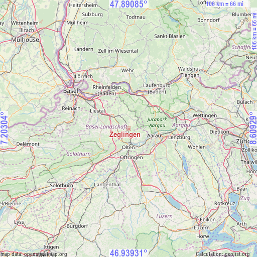
Zeglingen GPS coordinates[2]
47° 25' 2.028" North, 7° 54' 22.176" East
| Map corner | latitude | longitude |
|---|---|---|
| Upper-left | 47.89085°, | 7.20304° |
| Center: | 47.41723°, | 7.90616° |
| Lower-right: | 46.93931°, | 8.60929° |
| Map W x H: | 105.8×105.8 km | = 65.7×65.7mi |
| max Lat: | 47.76737° ⇑22.9% North |
| Zeglingen: | 47.41723° |
| min Lat: | ⇓77.1% South 45.83203° |
| min Long | Zeglingen | max Long |
| 5.97153° | 7.90616° | 10.44624° |
| W 37.8%⇐ | ⇒62.2% E |
Elevation
Elevation of Zeglingen is 540 m = 1772 ft, and this is 18.2 m = 60 ft below average elevation for this country.
| Max E: |
1845 m = 6053 ft | 36.4% |
| Avg. | 558.2 m = 1831 ft | |
| Zeglingen | 540 m = 1772 ft | |
Min E: |
197 m = 646 ft | 63.6% |
See also: Switzerland elevation on elevation.city.
Geographical zone
Zeglingen is located in North temperate zone (between Tropic of Cancer and the Arctic Circle). Distance of this North polar circle is 2128.9 km =1322.8 mi to North.| Distance of | km | miles | from Zeglingen |
|---|---|---|---|
| North Pole | 4734.8 | 2942.1 | to North |
| Arctic Circle | 2128.9 | 1322.8 | to North |
| Tropic Cancer | 2666.4 | 1656.8 | to South |
| Equator | 5272.3 | 3276.1 | to South |


Nearby cities:
15 places around Zeglingen: (largest is in red/bold)
• Buckten
4.7 km =2.9 mi,  259°
259°
• Diegten
7.2 km =4.5 mi,  266°
266°
• Erlinsbach
8 km =5 mi,  105°
105°
• Gelterkinden
6.7 km =4.2 mi,  322°
322°
• Känerkinden
5.2 km =3.2 mi, 263°
• Lostorf
4.8 km =3 mi,  140°
140°
• Läufelfingen
4.6 km =2.9 mi,  236°
236°
• Obergösgen
6.7 km =4.2 mi,  149°
149°
• Olten
7.5 km =4.7 mi,  181°
181°
• Ormalingen
6.3 km =3.9 mi,  336°
336°
• Rohr
3.6 km =2.2 mi,  102°
102°
• Rünenberg
2.5 km =1.6 mi, 315°
• Tecknau
3.9 km =2.4 mi, 335°
• Tenniken
7.5 km =4.7 mi,  287°
287°
• Trimbach
5.9 km =3.7 mi,  194°
194°
Sources, notices
• [Note1] Compared only with cities in Switzerland existing in our database
• [Src1] Map data: © OpenStreetMap contributors (CC-BY-SA)
• [Src2] Other city data from geonames.org with taken over terms of usage.
• [Src3] Geographical zone / Annual Mean Temperature by Robert A. Rohde @ Wikipedia
