Rohr geodata
Rohr (Solothurn) is a populated place; located in Switzerland in Europe/Zurich (GMT+2) time zone. With population of 2,849 people, there are 616 cities with bigger population in this country. Compared to other cities in Switzerland, 75.9% of cities are located further ↓South; 61.3% of cities are located further →East and 72.3% of cities have lower elevation than Rohr. Note1


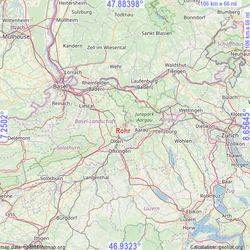
Rohr GPS coordinates[2]
47° 24' 37.044" North, 7° 57' 11.988" East
| Map corner | latitude | longitude |
|---|---|---|
| Upper-left | 47.88398°, | 7.2502° |
| Center: | 47.41029°, | 7.95333° |
| Lower-right: | 46.9323°, | 8.65645° |
| Map W x H: | 105.8×105.8 km | = 65.7×65.7mi |
| max Lat: | 47.76737° ⇑24.1% North |
| Rohr: | 47.41029° |
| min Lat: | ⇓75.9% South 45.83203° |
| min Long | Rohr | max Long |
| 5.97153° | 7.95333° | 10.44624° |
| W 38.7%⇐ | ⇒61.3% E |
Elevation
Elevation of Rohr is 590 m = 1936 ft, and this is 31.8 m = 104 ft above average elevation for this country.
| Max E: |
1845 m = 6053 ft | 27.7% |
| Rohr | 590 m 1936 ft | |
| Avg. | 558.2 m = 1831 ft | |
Min E: |
197 m = 646 ft | 72.3% |
See also: Switzerland elevation on elevation.city.
Geographical zone
Rohr is located in North temperate zone (between Tropic of Cancer and the Arctic Circle). Distance of this North polar circle is 2129.6 km =1323.3 mi to North.| Distance of | km | miles | from Rohr |
|---|---|---|---|
| North Pole | 4735.5 | 2942.5 | to North |
| Arctic Circle | 2129.6 | 1323.3 | to North |
| Tropic Cancer | 2665.6 | 1656.3 | to South |
| Equator | 5271.5 | 3275.6 | to South |


Nearby cities:
15 places around Rohr: (largest is in red/bold)
• Aarau
7.1 km =4.4 mi,  106°
106°
• Erlinsbach
4.3 km =2.7 mi, 109°
• Küttigen
7.3 km =4.5 mi,  86°
86°
• Lostorf
3 km =1.9 mi,  189°
189°
• Läufelfingen
7.5 km =4.7 mi,  256°
256°
• Niedergösgen
5 km =3.1 mi,  148°
148°
• Obergösgen
5 km =3.1 mi,  181°
181°
• Oberhof
5.7 km =3.5 mi,  40°
40°
• Olten
7.7 km =4.8 mi,  209°
209°
• Rünenberg
5.9 km =3.7 mi,  295°
295°
• Schönenwerd
5.8 km =3.6 mi,  141°
141°
• Tecknau
6.7 km =4.2 mi,  309°
309°
• Trimbach
7.1 km =4.4 mi,  225°
225°
• Wölflinswil
6.5 km =4 mi,  31°
31°
• Zeglingen
3.6 km =2.2 mi,  282°
282°
Sources, notices
• [Note1] Compared only with cities in Switzerland existing in our database
• [Src1] Map data: © OpenStreetMap contributors (CC-BY-SA)
• [Src2] Other city data from geonames.org with taken over terms of usage.
• [Src3] Geographical zone / Annual Mean Temperature by Robert A. Rohde @ Wikipedia
