Tägerwilen geodata
Tägerwilen (Thurgau) is a populated place; located in Switzerland in Europe/Zurich (GMT+2) time zone. With population of 3,414 people, there are 518 cities with bigger population in this country. Compared to other cities in Switzerland, 98.5% of cities are located further ↓South; 91.8% of cities are located further ←West and 87.1% of cities have higher elevation than Tägerwilen. Note1


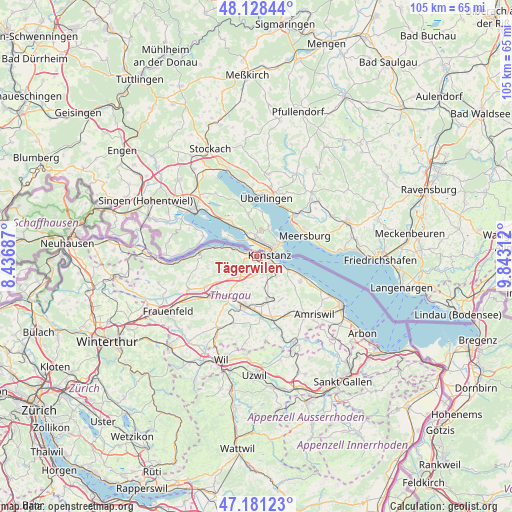
Tägerwilen GPS coordinates[2]
47° 39' 25.128" North, 9° 8' 23.964" East
| Map corner | latitude | longitude |
|---|---|---|
| Upper-left | 48.12844°, | 8.43687° |
| Center: | 47.65698°, | 9.13999° |
| Lower-right: | 47.18123°, | 9.84312° |
| Map W x H: | 105.3×105.3 km | = 65.4×65.4mi |
| max Lat: | 47.76737° ⇑1.5% North |
| Tägerwilen: | 47.65698° |
| min Lat: | ⇓98.5% South 45.83203° |
| min Long | Tägerwilen | max Long |
| 5.97153° | 9.13999° | 10.44624° |
| W 91.8%⇐ | ⇒8.2% E |
Elevation
Elevation of Tägerwilen is 404 m = 1325 ft, and this is 154.2 m = 506 ft below average elevation for this country.
| Max E: |
1845 m = 6053 ft | 87.1% |
| Avg. | 558.2 m = 1831 ft | |
| Tägerwilen | 404 m = 1325 ft | |
Min E: |
197 m = 646 ft | 12.9% |
See also: Switzerland elevation on elevation.city.
Geographical zone
Tägerwilen is located in North temperate zone (between Tropic of Cancer and the Arctic Circle). Distance of this North polar circle is 2102.2 km =1306.2 mi to North.| Distance of | km | miles | from Tägerwilen |
|---|---|---|---|
| North Pole | 4708.1 | 2925.5 | to North |
| Arctic Circle | 2102.2 | 1306.2 | to North |
| Tropic Cancer | 2693 | 1673.4 | to South |
| Equator | 5299 | 3292.6 | to South |


Nearby cities:
15 places around Tägerwilen: (largest is in red/bold)
• Altnau
10.5 km =6.5 mi,  119°
119°
• Berg
8.9 km =5.5 mi,  167°
167°
• Bottighofen
5.6 km =3.5 mi,  113°
113°
• Ermatingen
4.3 km =2.7 mi,  290°
290°
• Gottlieben
0.9 km =0.6 mi,  328°
328°
• Homburg
10.2 km =6.3 mi,  255°
255°
• Kreuzlingen
2.7 km =1.7 mi, 105°
• Langrickenbach
10.7 km =6.6 mi,  131°
131°
• Märstetten-Dorf
8.9 km =5.5 mi,  216°
216°
• Müllheim
11.9 km =7.4 mi,  239°
239°
• Münsterlingen
7.5 km =4.7 mi, 111°
• Steckborn
11.8 km =7.3 mi,  275°
275°
• Weinfelden
10.5 km =6.5 mi,  196°
196°
• Wigoltingen
10.5 km =6.5 mi,  230°
230°
• Wäldi
4.2 km =2.6 mi, 233°
Sources, notices
• [Note1] Compared only with cities in Switzerland existing in our database
• [Src1] Map data: © OpenStreetMap contributors (CC-BY-SA)
• [Src2] Other city data from geonames.org with taken over terms of usage.
• [Src3] Geographical zone / Annual Mean Temperature by Robert A. Rohde @ Wikipedia
