Sarnen geodata
Sarnen (Obwalden) is a seat of a first-order administrative division; located in Switzerland in Europe/Zurich (GMT+2) time zone. With population of 9,410 people, there are 164 cities with bigger population in this country. Compared to other cities in Switzerland, 69.8% of cities are located further ↑North; 54.4% of cities are located further →East and 52.4% of cities have higher elevation than Sarnen. Note1


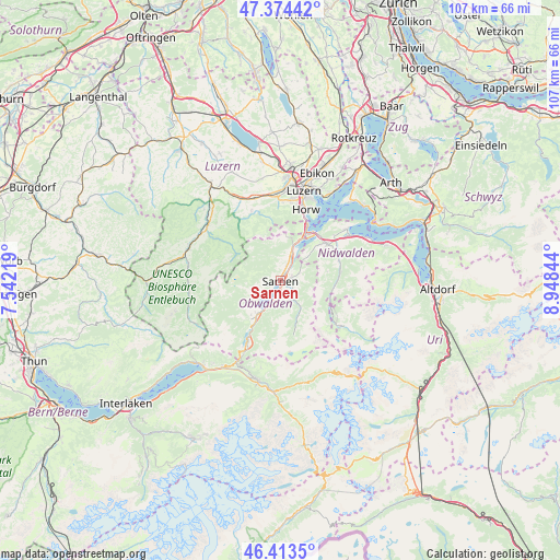
Sarnen GPS coordinates[2]
46° 53' 45.996" North, 8° 14' 43.116" East
| Map corner | latitude | longitude |
|---|---|---|
| Upper-left | 47.37442°, | 7.54219° |
| Center: | 46.89611°, | 8.24531° |
| Lower-right: | 46.4135°, | 8.94844° |
| Map W x H: | 106.8×106.8 km | = 66.4×66.4mi |
| max Lat: | 47.76737° ⇑69.8% North |
| Sarnen: | 46.89611° |
| min Lat: | ⇓30.2% South 45.83203° |
| min Long | Sarnen | max Long |
| 5.97153° | 8.24531° | 10.44624° |
| W 45.6%⇐ | ⇒54.4% E |
Elevation
Elevation of Sarnen is 473 m = 1552 ft, and this is 85.2 m = 280 ft below average elevation for this country.
| Max E: |
1845 m = 6053 ft | 52.4% |
| Avg. | 558.2 m = 1831 ft | |
| Sarnen | 473 m = 1552 ft | |
Min E: |
197 m = 646 ft | 47.6% |
See also: Switzerland elevation on elevation.city.
Geographical zone
Sarnen is located in North temperate zone (between Tropic of Cancer and the Arctic Circle). Distance of this North polar circle is 2186.8 km =1358.8 mi to North.| Distance of | km | miles | from Sarnen |
|---|---|---|---|
| North Pole | 4792.7 | 2978 | to North |
| Arctic Circle | 2186.8 | 1358.8 | to North |
| Tropic Cancer | 2608.4 | 1620.8 | to South |
| Equator | 5214.4 | 3240.1 | to South |


Nearby cities:
15 places around Sarnen: (largest is in red/bold)
• Alpnach
5.5 km =3.4 mi,  21°
21°
• Dallenwil
11.3 km =7 mi,  73°
73°
• Engelberg
14.5 km =9 mi,  125°
125°
• Ennetbürgen
15.9 km =9.9 mi,  51°
51°
• Giswil
8.5 km =5.3 mi,  215°
215°
• Hergiswil
10.9 km =6.8 mi,  26°
26°
• Horw
14.3 km =8.9 mi, 19°
• Kerns
2.3 km =1.4 mi,  75°
75°
• Kriens
15.3 km =9.5 mi,  11°
11°
• Lungern
13.9 km =8.6 mi,  207°
207°
• Sachseln
3.3 km =2.1 mi,  195°
195°
• Schwarzenberg
14.5 km =9 mi,  337°
337°
• Stans
11.5 km =7.1 mi, 53°
• Stansstad
11.3 km =7 mi,  37°
37°
• Wolfenschiessen
11.3 km =7 mi,  86°
86°
Sources, notices
• [Note1] Compared only with cities in Switzerland existing in our database
• [Src1] Map data: © OpenStreetMap contributors (CC-BY-SA)
• [Src2] Other city data from geonames.org with taken over terms of usage.
• [Src3] Geographical zone / Annual Mean Temperature by Robert A. Rohde @ Wikipedia
