Engelberg geodata
Engelberg (Obwalden) is a populated place; located in Switzerland in Europe/Zurich (GMT+2) time zone. With population of 4,001 people, there are 441 cities with bigger population in this country. Compared to other cities in Switzerland, 73.3% of cities are located further ↑North; 50.2% of cities are located further →East and 94.8% of cities have lower elevation than Engelberg. Note1


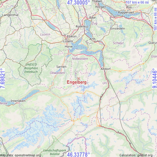
Engelberg GPS coordinates[2]
46° 49' 15.852" North, 8° 24' 4.788" East
| Map corner | latitude | longitude |
|---|---|---|
| Upper-left | 47.30005°, | 7.69821° |
| Center: | 46.82107°, | 8.40133° |
| Lower-right: | 46.33778°, | 9.10446° |
| Map W x H: | 107×107 km | = 66.5×66.5mi |
| max Lat: | 47.76737° ⇑73.3% North |
| Engelberg: | 46.82107° |
| min Lat: | ⇓26.7% South 45.83203° |
| min Long | Engelberg | max Long |
| 5.97153° | 8.40133° | 10.44624° |
| W 49.8%⇐ | ⇒50.2% E |
Elevation
Elevation of Engelberg is 1001 m = 3284 ft, and this is 442.8 m = 1453 ft above average elevation for this country.
| Max E: |
1845 m = 6053 ft | 5.2% |
| Engelberg | 1001 m 3284 ft | |
| Avg. | 558.2 m = 1831 ft | |
Min E: |
197 m = 646 ft | 94.8% |
See also: Switzerland elevation on elevation.city.
Geographical zone
Engelberg is located in North temperate zone (between Tropic of Cancer and the Arctic Circle). Distance of this North polar circle is 2195.2 km =1364 mi to North.| Distance of | km | miles | from Engelberg |
|---|---|---|---|
| North Pole | 4801 | 2983.2 | to North |
| Arctic Circle | 2195.2 | 1364 | to North |
| Tropic Cancer | 2600.1 | 1615.6 | to South |
| Equator | 5206 | 3234.9 | to South |


Nearby cities:
15 places around Engelberg: (largest is in red/bold)
• Alpnach
16.7 km =10.4 mi,  323°
323°
• Attinghausen
18 km =11.2 mi,  75°
75°
• Beckenried
17.1 km =10.6 mi,  19°
19°
• Buochs
17.1 km =10.6 mi,  5°
5°
• Dallenwil
11.5 km =7.1 mi,  354°
354°
• Emmetten
17.4 km =10.8 mi,  29°
29°
• Giswil
16.8 km =10.4 mi,  274°
274°
• Isenthal
15.7 km =9.8 mi,  50°
50°
• Kerns
13.1 km =8.1 mi,  312°
312°
• Sachseln
13.8 km =8.6 mi,  291°
291°
• Sarnen
14.5 km =9 mi, 305°
• Seedorf
17.7 km =11 mi,  67°
67°
• Stans
15.5 km =9.6 mi, 350°
• Stansstad
18 km =11.2 mi,  343°
343°
• Wolfenschiessen
9.2 km =5.7 mi,  356°
356°
Sources, notices
• [Note1] Compared only with cities in Switzerland existing in our database
• [Src1] Map data: © OpenStreetMap contributors (CC-BY-SA)
• [Src2] Other city data from geonames.org with taken over terms of usage.
• [Src3] Geographical zone / Annual Mean Temperature by Robert A. Rohde @ Wikipedia
