Tabou geodata
Tabou (Bas-Sassandra) is a seat of a third-order administrative division; located in Ivory Coast in Africa/Abidjan (GMT+0) time zone. With population of 17,134 people, there are 53 cities with bigger population in this country. Compared to other cities in Ivory Coast, 100% of cities are located further ↑North; 82.9% of cities are located further →East and 99.1% of cities have higher elevation than Tabou. Note1


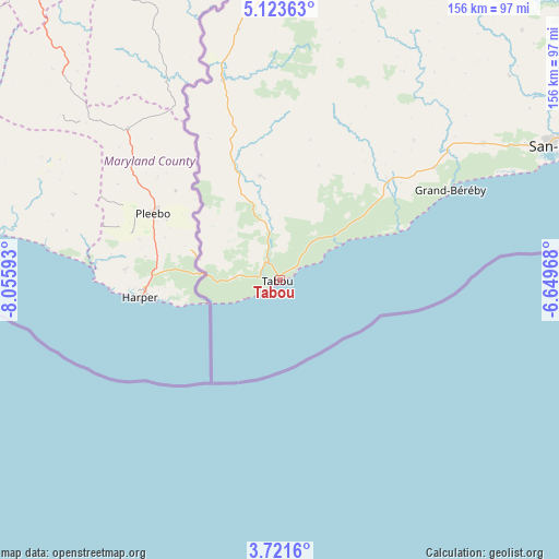
Tabou GPS coordinates[2]
4° 25' 22.62" North, 7° 21' 10.08" West
| Map corner | latitude | longitude |
|---|---|---|
| Upper-left | 5.12363°, | -8.05593° |
| Center: | 4.42295°, | -7.3528° |
| Lower-right: | 3.7216°, | -6.64968° |
| Map W x H: | 155.9×155.9 km | = 96.9×96.9mi |
| max Lat: | 10.48115° ⇑100% North |
| Tabou: | 4.42295° |
| min Lat: | ⇓0% South 4.42295° |
| min Long | Tabou | max Long |
| -8.42592° | -7.3528° | -2.80003° |
| W 17.1%⇐ | ⇒82.9% E |
Elevation
Elevation of Tabou is 9 m = 30 ft, and this is 215.3 m = 706 ft below average elevation for this country.
| Max E: |
556 m = 1824 ft | 99.1% |
| Avg. | 224.3 m = 736 ft | |
| Tabou | 9 m = 30 ft | |
Min E: |
7 m = 23 ft | 0.9% |
See also: Ivory Coast elevation on elevation.city.
Geographical zone
Tabou is located in North Torrid zone (between Equator and Tropic of Cancer). Distance of Equator is 491.8 km =305.6 mi to South.| Distance of | km | miles | from Tabou |
|---|---|---|---|
| North Pole | 9515.3 | 5912.5 | to North |
| Arctic Circle | 6909.4 | 4293.3 | to North |
| Tropic Cancer | 2114.1 | 1313.6 | to North |
| Equator | 491.8 | 305.6 | to South |


Nearby cities:
15 places around Tabou: (largest is in red/bold)
• Bloléquin
249.2 km =154.8 mi,  343°
343°
• Buyo
209.7 km =130.3 mi,  10°
10°
• Duekoué
257.9 km =160.3 mi,  0°
0°
• Fresco
210.8 km =131 mi,  69°
69°
• Gagnoa
245.4 km =152.5 mi,  39°
39°
• Guibéroua
240.5 km =149.4 mi,  32°
32°
• Guiglo
236.3 km =146.8 mi,  356°
356°
• Guitry
263.9 km =164 mi,  62°
62°
• Guéyo
199.8 km =124.1 mi,  45°
45°
• Issia
245.3 km =152.4 mi,  20°
20°
• Lakota
243.6 km =151.4 mi, 49°
• San-Pédro
87.3 km =54.2 mi, 65°
• Sassandra
152.4 km =94.7 mi, 67°
• Soubré
173.1 km =107.6 mi, 29°
• Taï
161.7 km =100.5 mi, 355°
Sources, notices
• [Note1] Compared only with cities in Ivory Coast existing in our database
• [Src1] Map data: © OpenStreetMap contributors (CC-BY-SA)
• [Src2] Other city data from geonames.org with taken over terms of usage.
• [Src3] Geographical zone / Annual Mean Temperature by Robert A. Rohde @ Wikipedia
