Fresco geodata
Fresco (Bas-Sassandra) is a seat of a third-order administrative division; located in Ivory Coast in Africa/Abidjan (GMT+0) time zone. In our database, there are 63 cities with bigger population. Compared to other cities in Ivory Coast, 97.4% of cities are located further ↑North; 55.6% of cities are located further →East and 85.5% of cities have higher elevation than Fresco. Note1


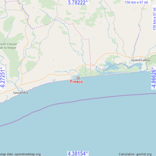
Fresco GPS coordinates[2]
5° 4' 56.136" North, 5° 34' 9.768" West
| Map corner | latitude | longitude |
|---|---|---|
| Upper-left | 5.78222°, | -6.27251° |
| Center: | 5.08226°, | -5.56938° |
| Lower-right: | 4.38154°, | -4.86626° |
| Map W x H: | 155.7×155.7 km | = 96.7×96.7mi |
| max Lat: | 10.48115° ⇑97.4% North |
| Fresco: | 5.08226° |
| min Lat: | ⇓2.6% South 4.42295° |
| min Long | Fresco | max Long |
| -8.42592° | -5.56938° | -2.80003° |
| W 44.4%⇐ | ⇒55.6% E |
Elevation
Elevation of Fresco is 69 m = 226 ft, and this is 155.3 m = 510 ft below average elevation for this country.
| Max E: |
556 m = 1824 ft | 85.5% |
| Avg. | 224.3 m = 736 ft | |
| Fresco | 69 m = 226 ft | |
Min E: |
7 m = 23 ft | 14.5% |
See also: Ivory Coast elevation on elevation.city.
Geographical zone
Fresco is located in North Torrid zone (between Equator and Tropic of Cancer). Distance of Equator is 565.1 km =351.1 mi to South.| Distance of | km | miles | from Fresco |
|---|---|---|---|
| North Pole | 9442 | 5867 | to North |
| Arctic Circle | 6836.1 | 4247.8 | to North |
| Tropic Cancer | 2040.8 | 1268.1 | to North |
| Equator | 565.1 | 351.1 | to South |


Nearby cities:
15 places around Fresco: (largest is in red/bold)
• Dabou
134.8 km =83.8 mi,  78°
78°
• Divo
87.2 km =54.2 mi,  15°
15°
• Gagnoa
124.1 km =77.1 mi,  340°
340°
• Grand-Lahou
65.4 km =40.6 mi,  73°
73°
• Guibéroua
144.8 km =90 mi,  332°
332°
• Guitry
60.7 km =37.7 mi,  36°
36°
• Guéyo
87.3 km =54.2 mi,  320°
320°
• Jacqueville
128.6 km =79.9 mi, 83°
• Lakota
86 km =53.4 mi,  351°
351°
• San-Pédro
123.9 km =77 mi,  252°
252°
• Sassandra
58.9 km =36.6 mi,  255°
255°
• Sikensi
128 km =79.5 mi,  59°
59°
• Soubré
137.6 km =85.5 mi,  304°
304°
• Taabo
134.3 km =83.5 mi, 22°
• Tiassalé
122.7 km =76.2 mi, 42°
Sources, notices
• [Note1] Compared only with cities in Ivory Coast existing in our database
• [Src1] Map data: © OpenStreetMap contributors (CC-BY-SA)
• [Src2] Other city data from geonames.org with taken over terms of usage.
• [Src3] Geographical zone / Annual Mean Temperature by Robert A. Rohde @ Wikipedia
