Guéyo geodata
Guéyo (Bas-Sassandra) is a seat of a third-order administrative division; located in Ivory Coast in Africa/Abidjan (GMT+0) time zone. In our database, there are 63 cities with bigger population. Compared to other cities in Ivory Coast, 80.3% of cities are located further ↑North; 65% of cities are located further →East and 63.2% of cities have higher elevation than Guéyo. Note1


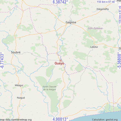
Guéyo GPS coordinates[2]
5° 41' 17.52" North, 6° 4' 16.32" West
| Map corner | latitude | longitude |
|---|---|---|
| Upper-left | 6.38742°, | -6.77433° |
| Center: | 5.6882°, | -6.0712° |
| Lower-right: | 4.98813°, | -5.36808° |
| Map W x H: | 155.6×155.6 km | = 96.7×96.7mi |
| max Lat: | 10.48115° ⇑80.3% North |
| Guéyo: | 5.6882° |
| min Lat: | ⇓19.7% South 4.42295° |
| min Long | Guéyo | max Long |
| -8.42592° | -6.0712° | -2.80003° |
| W 35%⇐ | ⇒65% E |
Elevation
Elevation of Guéyo is 188 m = 617 ft, and this is 36.3 m = 119 ft below average elevation for this country.
| Max E: |
556 m = 1824 ft | 63.2% |
| Avg. | 224.3 m = 736 ft | |
| Guéyo | 188 m = 617 ft | |
Min E: |
7 m = 23 ft | 36.8% |
See also: Ivory Coast elevation on elevation.city.
Geographical zone
Guéyo is located in North Torrid zone (between Equator and Tropic of Cancer). Distance of Equator is 632.5 km =393 mi to South.| Distance of | km | miles | from Guéyo |
|---|---|---|---|
| North Pole | 9374.6 | 5825.1 | to North |
| Arctic Circle | 6768.7 | 4205.9 | to North |
| Tropic Cancer | 1973.5 | 1226.3 | to North |
| Equator | 632.5 | 393 | to South |


Nearby cities:
15 places around Guéyo: (largest is in red/bold)
• Buyo
121.4 km =75.4 mi,  302°
302°
• Divo
80.7 km =50.1 mi,  78°
78°
• Fresco
87.3 km =54.2 mi,  140°
140°
• Gagnoa
51.1 km =31.8 mi,  15°
15°
• Grand-Lahou
127.8 km =79.4 mi,  112°
112°
• Guibéroua
62.2 km =38.6 mi,  349°
349°
• Guitry
93.8 km =58.3 mi,  101°
101°
• Issia
106 km =65.9 mi,  327°
327°
• Lakota
46.6 km =29 mi,  67°
67°
• Oumé
105.8 km =65.7 mi,  43°
43°
• San-Pédro
121.8 km =75.7 mi,  210°
210°
• Sassandra
81.7 km =50.8 mi,  181°
181°
• Sinfra
105.2 km =65.4 mi,  9°
9°
• Soubré
58.8 km =36.5 mi,  280°
280°
• Taabo
120.7 km =75 mi,  61°
61°
Sources, notices
• [Note1] Compared only with cities in Ivory Coast existing in our database
• [Src1] Map data: © OpenStreetMap contributors (CC-BY-SA)
• [Src2] Other city data from geonames.org with taken over terms of usage.
• [Src3] Geographical zone / Annual Mean Temperature by Robert A. Rohde @ Wikipedia
