Jacqueville geodata
Jacqueville (Lagunes) is a seat of a third-order administrative division; located in Ivory Coast in Africa/Abidjan (GMT+0) time zone. In our database, there are 63 cities with bigger population. Compared to other cities in Ivory Coast, 95.7% of cities are located further ↑North; 67.5% of cities are located further ←West and 96.6% of cities have higher elevation than Jacqueville. Note1


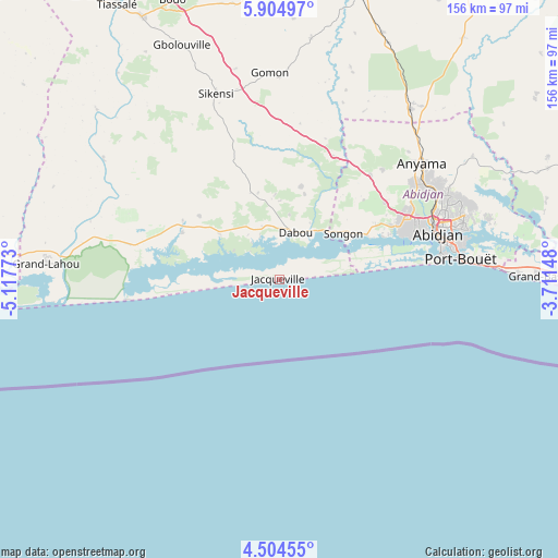
Jacqueville GPS coordinates[2]
5° 12' 18.54" North, 4° 24' 52.56" West
| Map corner | latitude | longitude |
|---|---|---|
| Upper-left | 5.90497°, | -5.11773° |
| Center: | 5.20515°, | -4.4146° |
| Lower-right: | 4.50455°, | -3.71148° |
| Map W x H: | 155.7×155.7 km | = 96.7×96.7mi |
| max Lat: | 10.48115° ⇑95.7% North |
| Jacqueville: | 5.20515° |
| min Lat: | ⇓4.3% South 4.42295° |
| min Long | Jacqueville | max Long |
| -8.42592° | -4.4146° | -2.80003° |
| W 67.5%⇐ | ⇒32.5% E |
Elevation
Elevation of Jacqueville is 12 m = 39 ft, and this is 212.3 m = 697 ft below average elevation for this country.
| Max E: |
556 m = 1824 ft | 96.6% |
| Avg. | 224.3 m = 736 ft | |
| Jacqueville | 12 m = 39 ft | |
Min E: |
7 m = 23 ft | 3.4% |
See also: Ivory Coast elevation on elevation.city.
Geographical zone
Jacqueville is located in North Torrid zone (between Equator and Tropic of Cancer). Distance of Equator is 578.8 km =359.6 mi to South.| Distance of | km | miles | from Jacqueville |
|---|---|---|---|
| North Pole | 9428.3 | 5858.5 | to North |
| Arctic Circle | 6822.4 | 4239.2 | to North |
| Tropic Cancer | 2027.2 | 1259.6 | to North |
| Equator | 578.8 | 359.6 | to South |


Nearby cities:
15 places around Jacqueville: (largest is in red/bold)
• Abidjan
46 km =28.6 mi,  75°
75°
• Abobo
50 km =31.1 mi,  62°
62°
• Agboville
83.4 km =51.8 mi,  15°
15°
• Alépé
89.4 km =55.6 mi,  68°
68°
• Anyama
51.5 km =32 mi,  51°
51°
• Azaguié
59.9 km =37.2 mi,  37°
37°
• Bingerville
60.9 km =37.8 mi, 74°
• Bonoua
90.9 km =56.5 mi,  85°
85°
• Dabou
14 km =8.7 mi, 17°
• Grand-Bassam
74.8 km =46.5 mi, 89°
• Grand-Lahou
65.4 km =40.6 mi,  274°
274°
• Guitry
97.9 km =60.8 mi,  290°
290°
• Sikensi
54.4 km =33.8 mi,  341°
341°
• Songon
21.9 km =13.6 mi, 54°
• Tiassalé
89.4 km =55.6 mi,  329°
329°
Sources, notices
• [Note1] Compared only with cities in Ivory Coast existing in our database
• [Src1] Map data: © OpenStreetMap contributors (CC-BY-SA)
• [Src2] Other city data from geonames.org with taken over terms of usage.
• [Src3] Geographical zone / Annual Mean Temperature by Robert A. Rohde @ Wikipedia
