Grand-Lahou geodata
Grand-Lahou (Lagunes) is a seat of a third-order administrative division; located in Ivory Coast in Africa/Abidjan (GMT+0) time zone. With population of 10,273 people, there are 62 cities with bigger population in this country. Compared to other cities in Ivory Coast, 94% of cities are located further ↑North; 59.8% of cities are located further ←West and 84.6% of cities have higher elevation than Grand-Lahou. Note1


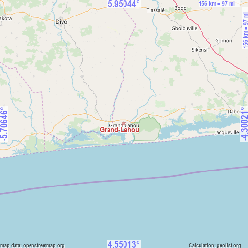
Grand-Lahou GPS coordinates[2]
5° 15' 2.448" North, 5° 0' 11.988" West
| Map corner | latitude | longitude |
|---|---|---|
| Upper-left | 5.95044°, | -5.70646° |
| Center: | 5.25068°, | -5.00333° |
| Lower-right: | 4.55013°, | -4.30021° |
| Map W x H: | 155.7×155.7 km | = 96.7×96.7mi |
| max Lat: | 10.48115° ⇑94% North |
| Grand-Lahou: | 5.25068° |
| min Lat: | ⇓6% South 4.42295° |
| min Long | Grand-Lahou | max Long |
| -8.42592° | -5.00333° | -2.80003° |
| W 59.8%⇐ | ⇒40.2% E |
Elevation
Elevation of Grand-Lahou is 77 m = 253 ft, and this is 147.3 m = 483 ft below average elevation for this country.
| Max E: |
556 m = 1824 ft | 84.6% |
| Avg. | 224.3 m = 736 ft | |
| Grand-Lahou | 77 m = 253 ft | |
Min E: |
7 m = 23 ft | 15.4% |
See also: Ivory Coast elevation on elevation.city.
Geographical zone
Grand-Lahou is located in North Torrid zone (between Equator and Tropic of Cancer). Distance of Equator is 583.8 km =362.8 mi to South.| Distance of | km | miles | from Grand-Lahou |
|---|---|---|---|
| North Pole | 9423.2 | 5855.3 | to North |
| Arctic Circle | 6817.4 | 4236.1 | to North |
| Tropic Cancer | 2022.1 | 1256.5 | to North |
| Equator | 583.8 | 362.8 | to South |


Nearby cities:
15 places around Grand-Lahou: (largest is in red/bold)
• Abidjan
109.9 km =68.3 mi,  86°
86°
• Abobo
110.9 km =68.9 mi,  80°
80°
• Agboville
115.4 km =71.7 mi,  49°
49°
• Anyama
108.8 km =67.6 mi, 75°
• Azaguié
110.3 km =68.5 mi,  67°
67°
• Dabou
69.9 km =43.4 mi, 83°
• Divo
76.1 km =47.3 mi,  329°
329°
• Fresco
65.4 km =40.6 mi,  253°
253°
• Guitry
39.8 km =24.7 mi,  318°
318°
• Jacqueville
65.4 km =40.6 mi, 94°
• Lakota
100.2 km =62.3 mi,  311°
311°
• Sikensi
66.5 km =41.3 mi, 45°
• Songon
83.3 km =51.8 mi, 84°
• Taabo
106.2 km =66 mi,  353°
353°
• Tiassalé
74.7 km =46.4 mi,  15°
15°
Sources, notices
• [Note1] Compared only with cities in Ivory Coast existing in our database
• [Src1] Map data: © OpenStreetMap contributors (CC-BY-SA)
• [Src2] Other city data from geonames.org with taken over terms of usage.
• [Src3] Geographical zone / Annual Mean Temperature by Robert A. Rohde @ Wikipedia
