Grand-Bassam geodata
Grand-Bassam (Comoé) is a seat of a third-order administrative division; located in Ivory Coast in Africa/Abidjan (GMT+0) time zone. With population of 73,772 people, there are 13 cities with bigger population in this country. Compared to other cities in Ivory Coast, 94.9% of cities are located further ↑North; 83.8% of cities are located further ←West and 100% of cities have higher elevation than Grand-Bassam. Note1


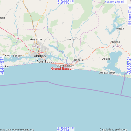
Grand-Bassam GPS coordinates[2]
5° 12' 42.48" North, 3° 44' 19.824" West
| Map corner | latitude | longitude |
|---|---|---|
| Upper-left | 5.91161°, | -4.44197° |
| Center: | 5.2118°, | -3.73884° |
| Lower-right: | 4.51121°, | -3.03572° |
| Map W x H: | 155.7×155.7 km | = 96.7×96.7mi |
| max Lat: | 10.48115° ⇑94.9% North |
| Grand-Bassam: | 5.2118° |
| min Lat: | ⇓5.1% South 4.42295° |
| min Long | Grand-Bassam | max Long |
| -8.42592° | -3.73884° | -2.80003° |
| W 83.8%⇐ | ⇒16.2% E |
Elevation
Elevation of Grand-Bassam is 7 m = 23 ft, and this is 217.3 m = 713 ft below average elevation for this country.
| Max E: |
556 m = 1824 ft | 100% |
| Avg. | 224.3 m = 736 ft | |
| Grand-Bassam | 7 m = 23 ft | |
Min E: |
7 m = 23 ft | 0% |
See also: Grand-Bassam elevation on elevation.city.
Geographical zone
Grand-Bassam is located in North Torrid zone (between Equator and Tropic of Cancer). Distance of Equator is 579.5 km =360.1 mi to South.| Distance of | km | miles | from Grand-Bassam |
|---|---|---|---|
| North Pole | 9427.6 | 5858 | to North |
| Arctic Circle | 6821.7 | 4238.8 | to North |
| Tropic Cancer | 2026.4 | 1259.1 | to North |
| Equator | 579.5 | 360.1 | to South |


Nearby cities:
15 places around Grand-Bassam: (largest is in red/bold)
• Abidjan
32.2 km =20 mi,  289°
289°
• Abobo
38.2 km =23.7 mi,  306°
306°
• Aboisso
65.4 km =40.6 mi,  64°
64°
• Adiaké
48.9 km =30.4 mi,  80°
80°
• Alépé
33.2 km =20.6 mi,  14°
14°
• Anyama
46.8 km =29.1 mi, 312°
• Ayamé
77.8 km =48.3 mi, 55°
• Azaguié
60 km =37.3 mi,  320°
320°
• Bingerville
22.8 km =14.2 mi, 314°
• Bonoua
17.2 km =10.7 mi,  66°
66°
• Dabou
71.8 km =44.6 mi,  280°
280°
• Jacqueville
74.8 km =46.5 mi,  269°
269°
• Maféré
81.7 km =50.8 mi, 73°
• Songon
58.3 km =36.2 mi, 281°
• Tiapoum
79.7 km =49.5 mi,  96°
96°
Sources, notices
• [Note1] Compared only with cities in Ivory Coast existing in our database
• [Src1] Map data: © OpenStreetMap contributors (CC-BY-SA)
• [Src2] Other city data from geonames.org with taken over terms of usage.
• [Src3] Geographical zone / Annual Mean Temperature by Robert A. Rohde @ Wikipedia
