Bingerville geodata
Bingerville (Abidjan) is a seat of a fourth-order administrative division; located in Ivory Coast in Africa/Abidjan (GMT+0) time zone. With population of 50,694 people, there are 25 cities with bigger population in this country. Compared to other cities in Ivory Coast, 88.9% of cities are located further ↑North; 82.1% of cities are located further ←West and 86.3% of cities have higher elevation than Bingerville. Note1


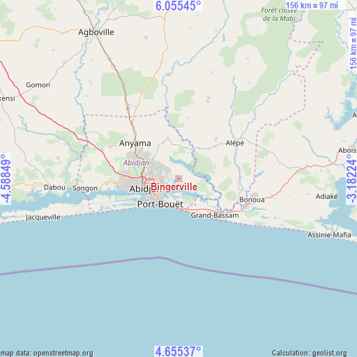
Bingerville GPS coordinates[2]
5° 21' 20.916" North, 3° 53' 7.332" West
| Map corner | latitude | longitude |
|---|---|---|
| Upper-left | 6.05545°, | -4.58849° |
| Center: | 5.35581°, | -3.88537° |
| Lower-right: | 4.65537°, | -3.18224° |
| Map W x H: | 155.7×155.7 km | = 96.7×96.7mi |
| max Lat: | 10.48115° ⇑88.9% North |
| Bingerville: | 5.35581° |
| min Lat: | ⇓11.1% South 4.42295° |
| min Long | Bingerville | max Long |
| -8.42592° | -3.88537° | -2.80003° |
| W 82.1%⇐ | ⇒17.9% E |
Elevation
Elevation of Bingerville is 59 m = 194 ft, and this is 165.3 m = 542 ft below average elevation for this country.
| Max E: |
556 m = 1824 ft | 86.3% |
| Avg. | 224.3 m = 736 ft | |
| Bingerville | 59 m = 194 ft | |
Min E: |
7 m = 23 ft | 13.7% |
See also: Bingerville elevation on elevation.city.
Geographical zone
Bingerville is located in North Torrid zone (between Equator and Tropic of Cancer). Distance of Equator is 595.5 km =370 mi to South.| Distance of | km | miles | from Bingerville |
|---|---|---|---|
| North Pole | 9411.6 | 5848.1 | to North |
| Arctic Circle | 6805.7 | 4228.9 | to North |
| Tropic Cancer | 2010.4 | 1249.2 | to North |
| Equator | 595.5 | 370 | to South |


Nearby cities:
15 places around Bingerville: (largest is in red/bold)
• Abidjan
15 km =9.3 mi,  249°
249°
• Abobo
15.9 km =9.9 mi,  294°
294°
• Aboisso
76.1 km =47.3 mi,  80°
80°
• Adiaké
64.8 km =40.3 mi,  96°
96°
• Adzopé
83.6 km =51.9 mi,  1°
1°
• Agboville
73.2 km =45.5 mi,  330°
330°
• Agou
70 km =43.5 mi,  354°
354°
• Alépé
29.4 km =18.3 mi,  56°
56°
• Anyama
24 km =14.9 mi,  309°
309°
• Azaguié
37.4 km =23.2 mi,  324°
324°
• Bonoua
33.3 km =20.7 mi,  106°
106°
• Dabou
54.5 km =33.9 mi,  266°
266°
• Grand-Bassam
22.8 km =14.2 mi,  134°
134°
• Jacqueville
60.9 km =37.8 mi, 254°
• Songon
41 km =25.5 mi,  264°
264°
Sources, notices
• [Note1] Compared only with cities in Ivory Coast existing in our database
• [Src1] Map data: © OpenStreetMap contributors (CC-BY-SA)
• [Src2] Other city data from geonames.org with taken over terms of usage.
• [Src3] Geographical zone / Annual Mean Temperature by Robert A. Rohde @ Wikipedia
