Bonoua geodata
Bonoua (Comoé) is a seat of a fourth-order administrative division; located in Ivory Coast in Africa/Abidjan (GMT+0) time zone. With population of 37,312 people, there are 38 cities with bigger population in this country. Compared to other cities in Ivory Coast, 93.2% of cities are located further ↑North; 87.2% of cities are located further ←West and 90.6% of cities have higher elevation than Bonoua. Note1
Administrative division(s):
- Level 1: Comoé
- Level 2: Sud-Comoé
- Level 3: Département de Grand-Bassam
- Level 4: Sous-préfecture de Bonoua


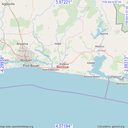
Bonoua GPS coordinates[2]
5° 16' 20.892" North, 3° 35' 46.5" West
| Map corner | latitude | longitude |
|---|---|---|
| Upper-left | 5.97221°, | -4.29938° |
| Center: | 5.27247°, | -3.59625° |
| Lower-right: | 4.57194°, | -2.89313° |
| Map W x H: | 155.7×155.7 km | = 96.7×96.7mi |
| max Lat: | 10.48115° ⇑93.2% North |
| Bonoua: | 5.27247° |
| min Lat: | ⇓6.8% South 4.42295° |
| min Long | Bonoua | max Long |
| -8.42592° | -3.59625° | -2.80003° |
| W 87.2%⇐ | ⇒12.8% E |
Elevation
Elevation of Bonoua is 30 m = 98 ft, and this is 194.3 m = 637 ft below average elevation for this country.
| Max E: |
556 m = 1824 ft | 90.6% |
| Avg. | 224.3 m = 736 ft | |
| Bonoua | 30 m = 98 ft | |
Min E: |
7 m = 23 ft | 9.4% |
See also: Ivory Coast elevation on elevation.city.
Geographical zone
Bonoua is located in North Torrid zone (between Equator and Tropic of Cancer). Distance of Equator is 586.2 km =364.2 mi to South.| Distance of | km | miles | from Bonoua |
|---|---|---|---|
| North Pole | 9420.8 | 5853.8 | to North |
| Arctic Circle | 6814.9 | 4234.6 | to North |
| Tropic Cancer | 2019.7 | 1255 | to North |
| Equator | 586.2 | 364.2 | to South |


Nearby cities:
15 places around Bonoua: (largest is in red/bold)
• Abidjan
46.3 km =28.8 mi,  275°
275°
• Abobo
49.1 km =30.5 mi,  288°
288°
• Aboisso
48.2 km =30 mi,  63°
63°
• Adiaké
32.4 km =20.1 mi,  87°
87°
• Agou
87.9 km =54.6 mi,  334°
334°
• Alépé
26.4 km =16.4 mi,  343°
343°
• Anyama
56.2 km =34.9 mi,  296°
296°
• Ayamé
61.1 km =38 mi,  52°
52°
• Azaguié
66.9 km =41.6 mi,  306°
306°
• Bingerville
33.3 km =20.7 mi, 286°
• Dabou
86.6 km =53.8 mi,  273°
273°
• Grand-Bassam
17.2 km =10.7 mi,  246°
246°
• Maféré
64.7 km =40.2 mi,  75°
75°
• Songon
73 km =45.4 mi, 274°
• Tiapoum
65.3 km =40.6 mi,  103°
103°
Sources, notices
• [Note1] Compared only with cities in Ivory Coast existing in our database
• [Src1] Map data: © OpenStreetMap contributors (CC-BY-SA)
• [Src2] Other city data from geonames.org with taken over terms of usage.
• [Src3] Geographical zone / Annual Mean Temperature by Robert A. Rohde @ Wikipedia
