Anyama geodata
Anyama (Abidjan) is a seat of a fourth-order administrative division; located in Ivory Coast in Africa/Abidjan (GMT+0) time zone. With population of 100,653 people, there are 11 cities with bigger population in this country. Compared to other cities in Ivory Coast, 85.5% of cities are located further ↑North; 74.4% of cities are located further ←West and 79.5% of cities have higher elevation than Anyama. Note1


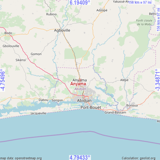
Anyama GPS coordinates[2]
5° 29' 40.632" North, 4° 3' 6.588" West
| Map corner | latitude | longitude |
|---|---|---|
| Upper-left | 6.19409°, | -4.75496° |
| Center: | 5.49462°, | -4.05183° |
| Lower-right: | 4.79433°, | -3.34871° |
| Map W x H: | 155.6×155.6 km | = 96.7×96.7mi |
| max Lat: | 10.48115° ⇑85.5% North |
| Anyama: | 5.49462° |
| min Lat: | ⇓14.5% South 4.42295° |
| min Long | Anyama | max Long |
| -8.42592° | -4.05183° | -2.80003° |
| W 74.4%⇐ | ⇒25.6% E |
Elevation
Elevation of Anyama is 95 m = 312 ft, and this is 129.3 m = 424 ft below average elevation for this country.
| Max E: |
556 m = 1824 ft | 79.5% |
| Avg. | 224.3 m = 736 ft | |
| Anyama | 95 m = 312 ft | |
Min E: |
7 m = 23 ft | 20.5% |
See also: Anyama elevation on elevation.city.
Geographical zone
Anyama is located in North Torrid zone (between Equator and Tropic of Cancer). Distance of Equator is 610.9 km =379.6 mi to South.| Distance of | km | miles | from Anyama |
|---|---|---|---|
| North Pole | 9396.1 | 5838.5 | to North |
| Arctic Circle | 6790.2 | 4219.2 | to North |
| Tropic Cancer | 1995 | 1239.6 | to North |
| Equator | 610.9 | 379.6 | to South |


Nearby cities:
15 places around Anyama: (largest is in red/bold)
• Abidjan
21 km =13 mi,  168°
168°
• Abobo
9.6 km =6 mi,  155°
155°
• Adiaké
86 km =53.4 mi,  105°
105°
• Adzopé
71.3 km =44.3 mi,  17°
17°
• Agboville
51.4 km =31.9 mi,  339°
339°
• Agou
55.6 km =34.5 mi,  12°
12°
• Alépé
43 km =26.7 mi,  89°
89°
• Azaguié
15.4 km =9.6 mi,  347°
347°
• Bingerville
24 km =14.9 mi,  129°
129°
• Bonoua
56.2 km =34.9 mi,  116°
116°
• Dabou
40.6 km =25.2 mi,  242°
242°
• Grand-Bassam
46.8 km =29.1 mi, 132°
• Jacqueville
51.5 km =32 mi,  231°
231°
• Sikensi
60.9 km =37.8 mi,  288°
288°
• Songon
29.7 km =18.5 mi, 229°
Sources, notices
• [Note1] Compared only with cities in Ivory Coast existing in our database
• [Src1] Map data: © OpenStreetMap contributors (CC-BY-SA)
• [Src2] Other city data from geonames.org with taken over terms of usage.
• [Src3] Geographical zone / Annual Mean Temperature by Robert A. Rohde @ Wikipedia
