Abobo geodata
Abobo (Abidjan) is a populated place; located in Ivory Coast in Africa/Abidjan (GMT+0) time zone. With population of 900,000 people, there is 1 city with bigger population in this country. Compared to other cities in Ivory Coast, 87.2% of cities are located further ↑North; 75.2% of cities are located further ←West and 78.6% of cities have higher elevation than Abobo. Note1


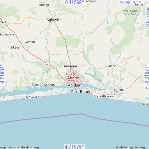
Abobo GPS coordinates[2]
5° 24' 58.068" North, 4° 0' 57.24" West
| Map corner | latitude | longitude |
|---|---|---|
| Upper-left | 6.11569°, | -4.71902° |
| Center: | 5.41613°, | -4.0159° |
| Lower-right: | 4.71576°, | -3.31277° |
| Map W x H: | 155.7×155.7 km | = 96.7×96.7mi |
| max Lat: | 10.48115° ⇑87.2% North |
| Abobo: | 5.41613° |
| min Lat: | ⇓12.8% South 4.42295° |
| min Long | Abobo | max Long |
| -8.42592° | -4.0159° | -2.80003° |
| W 75.2%⇐ | ⇒24.8% E |
Elevation
Elevation of Abobo is 105 m = 344 ft, and this is 119.3 m = 391 ft below average elevation for this country.
| Max E: |
556 m = 1824 ft | 78.6% |
| Avg. | 224.3 m = 736 ft | |
| Abobo | 105 m = 344 ft | |
Min E: |
7 m = 23 ft | 21.4% |
See also: Abobo elevation on elevation.city.
Geographical zone
Abobo is located in North Torrid zone (between Equator and Tropic of Cancer). Distance of Equator is 602.2 km =374.2 mi to South.| Distance of | km | miles | from Abobo |
|---|---|---|---|
| North Pole | 9404.8 | 5843.9 | to North |
| Arctic Circle | 6799 | 4224.7 | to North |
| Tropic Cancer | 2003.7 | 1245 | to North |
| Equator | 602.2 | 374.2 | to South |


Nearby cities:
15 places around Abobo: (largest is in red/bold)
• Abidjan
11.8 km =7.3 mi,  178°
178°
• Adiaké
80.1 km =49.8 mi,  100°
100°
• Adzopé
78.7 km =48.9 mi,  12°
12°
• Agboville
61 km =37.9 mi,  339°
339°
• Agou
63.5 km =39.5 mi, 7°
• Alépé
40.2 km =25 mi,  76°
76°
• Anyama
9.6 km =6 mi, 335°
• Azaguié
24.9 km =15.5 mi, 342°
• Bingerville
15.9 km =9.9 mi,  114°
114°
• Bonoua
49.1 km =30.5 mi, 108°
• Dabou
41.2 km =25.6 mi,  255°
255°
• Grand-Bassam
38.2 km =23.7 mi,  126°
126°
• Jacqueville
50 km =31.1 mi,  242°
242°
• Sikensi
67.8 km =42.1 mi,  294°
294°
• Songon
28.5 km =17.7 mi,  247°
247°
Sources, notices
• [Note1] Compared only with cities in Ivory Coast existing in our database
• [Src1] Map data: © OpenStreetMap contributors (CC-BY-SA)
• [Src2] Other city data from geonames.org with taken over terms of usage.
• [Src3] Geographical zone / Annual Mean Temperature by Robert A. Rohde @ Wikipedia
