Abidjan geodata
Abidjan is a seat of a first-order administrative division; located in Ivory Coast in Africa/Abidjan (GMT+0) time zone. With population of 3,677,115 people, there are 0 cities with bigger population in this country. Compared to other cities in Ivory Coast, 91.5% of cities are located further ↑North; 76.1% of cities are located further ←West and 97.4% of cities have higher elevation than Abidjan. Note1


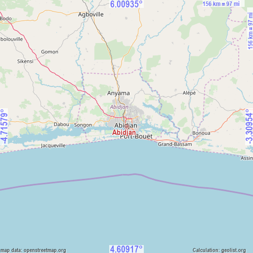
Abidjan GPS coordinates[2]
5° 18' 34.776" North, 4° 0' 45.576" West
| Map corner | latitude | longitude |
|---|---|---|
| Upper-left | 6.00935°, | -4.71579° |
| Center: | 5.30966°, | -4.01266° |
| Lower-right: | 4.60917°, | -3.30954° |
| Map W x H: | 155.7×155.7 km | = 96.7×96.7mi |
| max Lat: | 10.48115° ⇑91.5% North |
| Abidjan: | 5.30966° |
| min Lat: | ⇓8.5% South 4.42295° |
| min Long | Abidjan | max Long |
| -8.42592° | -4.01266° | -2.80003° |
| W 76.1%⇐ | ⇒23.9% E |
Elevation
Elevation of Abidjan is 10 m = 33 ft, and this is 214.3 m = 703 ft below average elevation for this country.
| Max E: |
556 m = 1824 ft | 97.4% |
| Avg. | 224.3 m = 736 ft | |
| Abidjan | 10 m = 33 ft | |
Min E: |
7 m = 23 ft | 2.6% |
See also: Abidjan elevation on elevation.city.
Geographical zone
Abidjan is located in North Torrid zone (between Equator and Tropic of Cancer). Distance of Equator is 590.4 km =366.9 mi to South.| Distance of | km | miles | from Abidjan |
|---|---|---|---|
| North Pole | 9416.7 | 5851.3 | to North |
| Arctic Circle | 6810.8 | 4232 | to North |
| Tropic Cancer | 2015.5 | 1252.4 | to North |
| Equator | 590.4 | 366.9 | to South |


Nearby cities:
15 places around Abidjan: (largest is in red/bold)
• Abobo
11.8 km =7.3 mi,  358°
358°
• Adiaké
78.5 km =48.8 mi,  91°
91°
• Adzopé
90.2 km =56 mi,  10°
10°
• Agboville
72.2 km =44.9 mi,  342°
342°
• Agou
75.2 km =46.7 mi, 5°
• Alépé
44.1 km =27.4 mi,  61°
61°
• Anyama
21 km =13 mi,  348°
348°
• Azaguié
36.4 km =22.6 mi, 347°
• Bingerville
15 km =9.3 mi,  69°
69°
• Bonoua
46.3 km =28.8 mi,  95°
95°
• Dabou
40.4 km =25.1 mi,  272°
272°
• Grand-Bassam
32.2 km =20 mi,  109°
109°
• Jacqueville
46 km =28.6 mi,  255°
255°
• Sikensi
73.8 km =45.9 mi,  302°
302°
• Songon
26.8 km =16.7 mi, 272°
Sources, notices
• [Note1] Compared only with cities in Ivory Coast existing in our database
• [Src1] Map data: © OpenStreetMap contributors (CC-BY-SA)
• [Src2] Other city data from geonames.org with taken over terms of usage.
• [Src3] Geographical zone / Annual Mean Temperature by Robert A. Rohde @ Wikipedia
