Azaguié geodata
Azaguié (Lagunes) is a seat of a fourth-order administrative division; located in Ivory Coast in Africa/Abidjan (GMT+0) time zone. In our database, there are 63 cities with bigger population. Compared to other cities in Ivory Coast, 82.1% of cities are located further ↑North; 73.5% of cities are located further ←West and 83.8% of cities have higher elevation than Azaguié. Note1


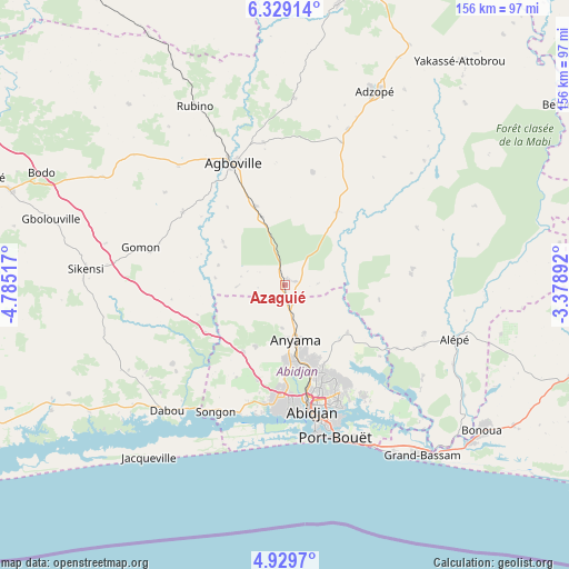
Azaguié GPS coordinates[2]
5° 37' 47.424" North, 4° 4' 55.344" West
| Map corner | latitude | longitude |
|---|---|---|
| Upper-left | 6.32914°, | -4.78517° |
| Center: | 5.62984°, | -4.08204° |
| Lower-right: | 4.9297°, | -3.37892° |
| Map W x H: | 155.6×155.6 km | = 96.7×96.7mi |
| max Lat: | 10.48115° ⇑82.1% North |
| Azaguié: | 5.62984° |
| min Lat: | ⇓17.9% South 4.42295° |
| min Long | Azaguié | max Long |
| -8.42592° | -4.08204° | -2.80003° |
| W 73.5%⇐ | ⇒26.5% E |
Elevation
Elevation of Azaguié is 81 m = 266 ft, and this is 143.3 m = 470 ft below average elevation for this country.
| Max E: |
556 m = 1824 ft | 83.8% |
| Avg. | 224.3 m = 736 ft | |
| Azaguié | 81 m = 266 ft | |
Min E: |
7 m = 23 ft | 16.2% |
See also: Ivory Coast elevation on elevation.city.
Geographical zone
Azaguié is located in North Torrid zone (between Equator and Tropic of Cancer). Distance of Equator is 626 km =389 mi to South.| Distance of | km | miles | from Azaguié |
|---|---|---|---|
| North Pole | 9381.1 | 5829.1 | to North |
| Arctic Circle | 6775.2 | 4209.9 | to North |
| Tropic Cancer | 1979.9 | 1230.3 | to North |
| Equator | 626 | 389 | to South |


Nearby cities:
15 places around Azaguié: (largest is in red/bold)
• Abidjan
36.4 km =22.6 mi,  167°
167°
• Abobo
24.9 km =15.5 mi,  162°
162°
• Adzopé
58.4 km =36.3 mi,  24°
24°
• Agboville
36.2 km =22.5 mi,  336°
336°
• Agou
42.1 km =26.2 mi, 21°
• Alépé
48.5 km =30.1 mi,  107°
107°
• Anyama
15.4 km =9.6 mi, 167°
• Bingerville
37.4 km =23.2 mi,  144°
144°
• Bonoua
66.9 km =41.6 mi,  126°
126°
• Dabou
47 km =29.2 mi,  223°
223°
• Grand-Bassam
60 km =37.3 mi, 140°
• Jacqueville
59.9 km =37.2 mi, 217°
• Sikensi
54.6 km =33.9 mi,  274°
274°
• Songon
39.4 km =24.5 mi,  208°
208°
• Yakassé-Attobrou
77.7 km =48.3 mi,  37°
37°
Sources, notices
• [Note1] Compared only with cities in Ivory Coast existing in our database
• [Src1] Map data: © OpenStreetMap contributors (CC-BY-SA)
• [Src2] Other city data from geonames.org with taken over terms of usage.
• [Src3] Geographical zone / Annual Mean Temperature by Robert A. Rohde @ Wikipedia
