Affery geodata
Affery (Lagunes) is a populated place; located in Ivory Coast in Africa/Abidjan (GMT+0) time zone. With population of 29,909 people, there are 44 cities with bigger population in this country. Compared to other cities in Ivory Coast, 67.5% of cities are located further ↑North; 79.5% of cities are located further ←West and 77.8% of cities have higher elevation than Affery. Note1


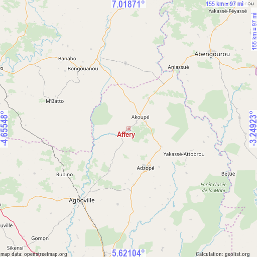
Affery GPS coordinates[2]
6° 19' 13.26" North, 3° 57' 8.46" West
| Map corner | latitude | longitude |
|---|---|---|
| Upper-left | 7.01871°, | -4.65548° |
| Center: | 6.32035°, | -3.95235° |
| Lower-right: | 5.62104°, | -3.24923° |
| Map W x H: | 155.4×155.4 km | = 96.6×96.6mi |
| max Lat: | 10.48115° ⇑67.5% North |
| Affery: | 6.32035° |
| min Lat: | ⇓32.5% South 4.42295° |
| min Long | Affery | max Long |
| -8.42592° | -3.95235° | -2.80003° |
| W 79.5%⇐ | ⇒20.5% E |
Elevation
Elevation of Affery is 106 m = 348 ft, and this is 118.3 m = 388 ft below average elevation for this country.
| Max E: |
556 m = 1824 ft | 77.8% |
| Avg. | 224.3 m = 736 ft | |
| Affery | 106 m = 348 ft | |
Min E: |
7 m = 23 ft | 22.2% |
See also: Ivory Coast elevation on elevation.city.
Geographical zone
Affery is located in North Torrid zone (between Equator and Tropic of Cancer). Distance of Equator is 702.8 km =436.7 mi to South.| Distance of | km | miles | from Affery |
|---|---|---|---|
| North Pole | 9304.3 | 5781.4 | to North |
| Arctic Circle | 6698.4 | 4162.2 | to North |
| Tropic Cancer | 1903.2 | 1182.6 | to North |
| Equator | 702.8 | 436.7 | to South |


Nearby cities:
15 places around Affery: (largest is in red/bold)
• Abengourou
67.9 km =42.2 mi,  47°
47°
• Adzopé
25.7 km =16 mi,  157°
157°
• Agboville
52.3 km =32.5 mi,  213°
213°
• Agou
37.5 km =23.3 mi,  178°
178°
• Akoupé
10.1 km =6.3 mi, 45°
• Alépé
96.6 km =60 mi, 160°
• Anyama
92.5 km =57.5 mi,  186°
186°
• Arrah
39.3 km =24.4 mi,  357°
357°
• Azaguié
78.1 km =48.5 mi, 190°
• Bongouanou
46.2 km =28.7 mi,  322°
322°
• Béttié
66 km =41 mi,  114°
114°
• Daoukro
82.1 km =51 mi, 359°
• Dimbokro
90.7 km =56.4 mi,  293°
293°
• M’Batto
47.9 km =29.8 mi, 290°
• Yakassé-Attobrou
36.7 km =22.8 mi, 114°
Sources, notices
• [Note1] Compared only with cities in Ivory Coast existing in our database
• [Src1] Map data: © OpenStreetMap contributors (CC-BY-SA)
• [Src2] Other city data from geonames.org with taken over terms of usage.
• [Src3] Geographical zone / Annual Mean Temperature by Robert A. Rohde @ Wikipedia
