Agou geodata
Agou (Lagunes) is a seat of a fourth-order administrative division; located in Ivory Coast in Africa/Abidjan (GMT+0) time zone. In our database, there are 63 cities with bigger population. Compared to other cities in Ivory Coast, 74.4% of cities are located further ↑North; 80.3% of cities are located further ←West and 81.2% of cities have higher elevation than Agou. Note1


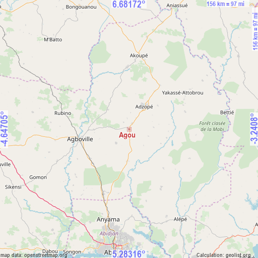
Agou GPS coordinates[2]
5° 58' 58.404" North, 3° 56' 38.148" West
| Map corner | latitude | longitude |
|---|---|---|
| Upper-left | 6.68172°, | -4.64705° |
| Center: | 5.98289°, | -3.94393° |
| Lower-right: | 5.28316°, | -3.2408° |
| Map W x H: | 155.5×155.5 km | = 96.6×96.6mi |
| max Lat: | 10.48115° ⇑74.4% North |
| Agou: | 5.98289° |
| min Lat: | ⇓25.6% South 4.42295° |
| min Long | Agou | max Long |
| -8.42592° | -3.94393° | -2.80003° |
| W 80.3%⇐ | ⇒19.7% E |
Elevation
Elevation of Agou is 93 m = 305 ft, and this is 131.3 m = 431 ft below average elevation for this country.
| Max E: |
556 m = 1824 ft | 81.2% |
| Avg. | 224.3 m = 736 ft | |
| Agou | 93 m = 305 ft | |
Min E: |
7 m = 23 ft | 18.8% |
See also: Ivory Coast elevation on elevation.city.
Geographical zone
Agou is located in North Torrid zone (between Equator and Tropic of Cancer). Distance of Equator is 665.2 km =413.3 mi to South.| Distance of | km | miles | from Agou |
|---|---|---|---|
| North Pole | 9341.8 | 5804.7 | to North |
| Arctic Circle | 6735.9 | 4185.5 | to North |
| Tropic Cancer | 1940.7 | 1205.9 | to North |
| Equator | 665.2 | 413.3 | to South |


Nearby cities:
15 places around Agou: (largest is in red/bold)
• Abidjan
75.2 km =46.7 mi,  185°
185°
• Abobo
63.5 km =39.5 mi, 187°
• Adzopé
16.5 km =10.3 mi,  33°
33°
• Affery
37.5 km =23.3 mi,  358°
358°
• Agboville
30.4 km =18.9 mi,  258°
258°
• Akoupé
45.1 km =28 mi,  7°
7°
• Alépé
62 km =38.5 mi,  149°
149°
• Anyama
55.6 km =34.5 mi, 192°
• Arrah
76.8 km =47.7 mi, 357°
• Azaguié
42.1 km =26.2 mi,  201°
201°
• Bingerville
70 km =43.5 mi,  174°
174°
• Béttié
60.1 km =37.3 mi,  80°
80°
• M’Batto
71.1 km =44.2 mi,  319°
319°
• Sikensi
78 km =48.5 mi,  243°
243°
• Yakassé-Attobrou
39.2 km =24.4 mi,  55°
55°
Sources, notices
• [Note1] Compared only with cities in Ivory Coast existing in our database
• [Src1] Map data: © OpenStreetMap contributors (CC-BY-SA)
• [Src2] Other city data from geonames.org with taken over terms of usage.
• [Src3] Geographical zone / Annual Mean Temperature by Robert A. Rohde @ Wikipedia
