Akoupé geodata
Akoupé (Lagunes) is a seat of a third-order administrative division; located in Ivory Coast in Africa/Abidjan (GMT+0) time zone. With population of 35,970 people, there are 39 cities with bigger population in this country. Compared to other cities in Ivory Coast, 65.8% of cities are located further ↑North; 81.2% of cities are located further ←West and 70.1% of cities have higher elevation than Akoupé. Note1


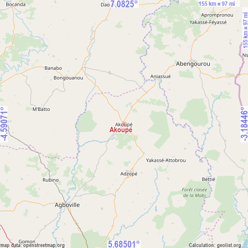
Akoupé GPS coordinates[2]
6° 23' 3.228" North, 3° 53' 15.324" West
| Map corner | latitude | longitude |
|---|---|---|
| Upper-left | 7.0825°, | -4.59071° |
| Center: | 6.38423°, | -3.88759° |
| Lower-right: | 5.68501°, | -3.18446° |
| Map W x H: | 155.4×155.4 km | = 96.6×96.6mi |
| max Lat: | 10.48115° ⇑65.8% North |
| Akoupé: | 6.38423° |
| min Lat: | ⇓34.2% South 4.42295° |
| min Long | Akoupé | max Long |
| -8.42592° | -3.88759° | -2.80003° |
| W 81.2%⇐ | ⇒18.8% E |
Elevation
Elevation of Akoupé is 142 m = 466 ft, and this is 82.3 m = 270 ft below average elevation for this country.
| Max E: |
556 m = 1824 ft | 70.1% |
| Avg. | 224.3 m = 736 ft | |
| Akoupé | 142 m = 466 ft | |
Min E: |
7 m = 23 ft | 29.9% |
See also: Ivory Coast elevation on elevation.city.
Geographical zone
Akoupé is located in North Torrid zone (between Equator and Tropic of Cancer). Distance of Equator is 709.9 km =441.1 mi to South.| Distance of | km | miles | from Akoupé |
|---|---|---|---|
| North Pole | 9297.2 | 5777 | to North |
| Arctic Circle | 6691.3 | 4157.8 | to North |
| Tropic Cancer | 1896.1 | 1178.2 | to North |
| Equator | 709.9 | 441.1 | to South |


Nearby cities:
15 places around Akoupé: (largest is in red/bold)
• Abengourou
57.8 km =35.9 mi,  48°
48°
• Adzopé
31 km =19.3 mi,  174°
174°
• Affery
10.1 km =6.3 mi,  225°
225°
• Agboville
62.2 km =38.6 mi,  215°
215°
• Agou
45.1 km =28 mi,  187°
187°
• Anyama
100.6 km =62.5 mi, 190°
• Arrah
33.4 km =20.8 mi,  344°
344°
• Azaguié
86.6 km =53.8 mi, 194°
• Bocanda
101.3 km =62.9 mi,  318°
318°
• Bongouanou
45.9 km =28.5 mi,  310°
310°
• Béttié
63.1 km =39.2 mi,  122°
122°
• Daoukro
75.5 km =46.9 mi,  353°
353°
• Dimbokro
94.9 km =59 mi,  287°
287°
• M’Batto
52.9 km =32.9 mi,  280°
280°
• Yakassé-Attobrou
34.5 km =21.4 mi,  130°
130°
Sources, notices
• [Note1] Compared only with cities in Ivory Coast existing in our database
• [Src1] Map data: © OpenStreetMap contributors (CC-BY-SA)
• [Src2] Other city data from geonames.org with taken over terms of usage.
• [Src3] Geographical zone / Annual Mean Temperature by Robert A. Rohde @ Wikipedia
