Adzopé geodata
Adzopé (Lagunes) is a seat of a second-order administrative division; located in Ivory Coast in Africa/Abidjan (GMT+0) time zone. With population of 61,884 people, there are 17 cities with bigger population in this country. Compared to other cities in Ivory Coast, 72.6% of cities are located further ↑North; 82.9% of cities are located further ←West and 76.9% of cities have higher elevation than Adzopé. Note1


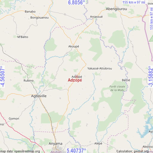
Adzopé GPS coordinates[2]
6° 6' 24.984" North, 3° 51' 42.984" West
| Map corner | latitude | longitude |
|---|---|---|
| Upper-left | 6.8056°, | -4.56507° |
| Center: | 6.10694°, | -3.86194° |
| Lower-right: | 5.40737°, | -3.15882° |
| Map W x H: | 155.5×155.5 km | = 96.6×96.6mi |
| max Lat: | 10.48115° ⇑72.6% North |
| Adzopé: | 6.10694° |
| min Lat: | ⇓27.4% South 4.42295° |
| min Long | Adzopé | max Long |
| -8.42592° | -3.86194° | -2.80003° |
| W 82.9%⇐ | ⇒17.1% E |
Elevation
Elevation of Adzopé is 109 m = 358 ft, and this is 115.3 m = 378 ft below average elevation for this country.
| Max E: |
556 m = 1824 ft | 76.9% |
| Avg. | 224.3 m = 736 ft | |
| Adzopé | 109 m = 358 ft | |
Min E: |
7 m = 23 ft | 23.1% |
See also: Adzopé elevation on elevation.city.
Geographical zone
Adzopé is located in North Torrid zone (between Equator and Tropic of Cancer). Distance of Equator is 679 km =421.9 mi to South.| Distance of | km | miles | from Adzopé |
|---|---|---|---|
| North Pole | 9328 | 5796.1 | to North |
| Arctic Circle | 6722.1 | 4176.9 | to North |
| Tropic Cancer | 1926.9 | 1197.3 | to North |
| Equator | 679 | 421.9 | to South |


Nearby cities:
15 places around Adzopé: (largest is in red/bold)
• Abengourou
80.2 km =49.8 mi,  30°
30°
• Abobo
78.7 km =48.9 mi,  192°
192°
• Affery
25.7 km =16 mi,  337°
337°
• Agboville
43.6 km =27.1 mi,  242°
242°
• Agou
16.5 km =10.3 mi,  213°
213°
• Akoupé
31 km =19.3 mi,  354°
354°
• Alépé
70.9 km =44.1 mi,  161°
161°
• Anyama
71.3 km =44.3 mi,  197°
197°
• Arrah
64.1 km =39.8 mi, 349°
• Azaguié
58.4 km =36.3 mi, 204°
• Bingerville
83.6 km =51.9 mi,  181°
181°
• Bongouanou
71.4 km =44.4 mi,  328°
328°
• Béttié
50.3 km =31.3 mi,  93°
93°
• M’Batto
68.2 km =42.4 mi,  306°
306°
• Yakassé-Attobrou
24.7 km =15.3 mi,  70°
70°
Sources, notices
• [Note1] Compared only with cities in Ivory Coast existing in our database
• [Src1] Map data: © OpenStreetMap contributors (CC-BY-SA)
• [Src2] Other city data from geonames.org with taken over terms of usage.
• [Src3] Geographical zone / Annual Mean Temperature by Robert A. Rohde @ Wikipedia
