Abengourou geodata
Abengourou (Comoé) is a seat of a first-order administrative division; located in Ivory Coast in Africa/Abidjan (GMT+0) time zone. With population of 104,020 people, there are 10 cities with bigger population in this country. Compared to other cities in Ivory Coast, 54.7% of cities are located further ↑North; 88.9% of cities are located further ←West and 59% of cities have higher elevation than Abengourou. Note1


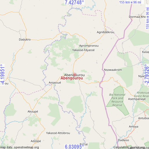
Abengourou GPS coordinates[2]
6° 43' 46.992" North, 3° 29' 47.004" West
| Map corner | latitude | longitude |
|---|---|---|
| Upper-left | 7.42748°, | -4.19951° |
| Center: | 6.72972°, | -3.49639° |
| Lower-right: | 6.03095°, | -2.79326° |
| Map W x H: | 155.3×155.3 km | = 96.5×96.5mi |
| max Lat: | 10.48115° ⇑54.7% North |
| Abengourou: | 6.72972° |
| min Lat: | ⇓45.3% South 4.42295° |
| min Long | Abengourou | max Long |
| -8.42592° | -3.49639° | -2.80003° |
| W 88.9%⇐ | ⇒11.1% E |
Elevation
Elevation of Abengourou is 197 m = 646 ft, and this is 27.3 m = 90 ft below average elevation for this country.
| Max E: |
556 m = 1824 ft | 59% |
| Avg. | 224.3 m = 736 ft | |
| Abengourou | 197 m = 646 ft | |
Min E: |
7 m = 23 ft | 41% |
See also: Abengourou elevation on elevation.city.
Geographical zone
Abengourou is located in North Torrid zone (between Equator and Tropic of Cancer). Distance of Equator is 748.3 km =465 mi to South.| Distance of | km | miles | from Abengourou |
|---|---|---|---|
| North Pole | 9258.8 | 5753.1 | to North |
| Arctic Circle | 6652.9 | 4133.9 | to North |
| Tropic Cancer | 1857.6 | 1154.3 | to North |
| Equator | 748.3 | 465 | to South |


Nearby cities:
15 places around Abengourou: (largest is in red/bold)
• Adzopé
80.2 km =49.8 mi,  210°
210°
• Affery
67.9 km =42.2 mi,  227°
227°
• Agnibilékrou
55.1 km =34.2 mi,  35°
35°
• Agou
96.7 km =60.1 mi, 210°
• Akoupé
57.8 km =35.9 mi, 228°
• Arrah
52.6 km =32.7 mi,  263°
263°
• Bocanda
116.7 km =72.5 mi,  288°
288°
• Bongouanou
78.6 km =48.8 mi, 263°
• Béttié
73.4 km =45.6 mi,  172°
172°
• Daoukro
63.2 km =39.3 mi,  305°
305°
• Koun-Fao
88.5 km =55 mi,  17°
17°
• M’Batto
99.4 km =61.8 mi,  253°
253°
• Prikro
115.9 km =72 mi,  331°
331°
• Transua
105.6 km =65.6 mi,  30°
30°
• Yakassé-Attobrou
63.3 km =39.3 mi,  195°
195°
Sources, notices
• [Note1] Compared only with cities in Ivory Coast existing in our database
• [Src1] Map data: © OpenStreetMap contributors (CC-BY-SA)
• [Src2] Other city data from geonames.org with taken over terms of usage.
• [Src3] Geographical zone / Annual Mean Temperature by Robert A. Rohde @ Wikipedia
