Ancud geodata
Ancud (Los Lagos Region) is a populated place; located in Chile in America/Santiago (GMT-4) time zone. With population of 28,020 people, there are 61 cities with bigger population in this country. Compared to other cities in Chile, 86.9% of cities are located further ↑North; 99.3% of cities are located further →East and 69% of cities have higher elevation than Ancud. Note1


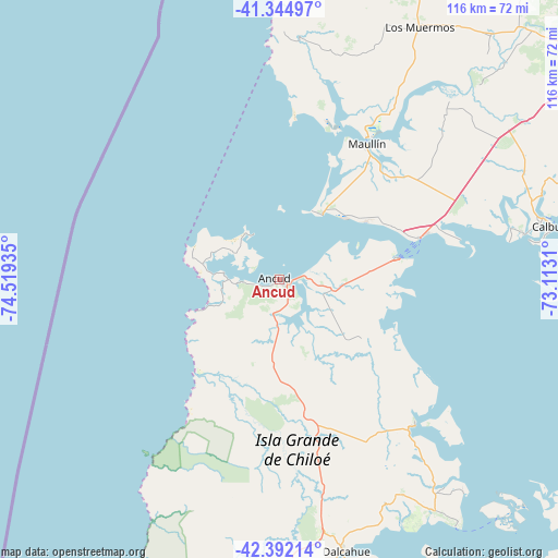
Ancud GPS coordinates[2]
41° 52' 14.52" South, 73° 48' 58.392" West
| Map corner | latitude | longitude |
|---|---|---|
| Upper-left | -41.34497°, | -74.51935° |
| Center: | -41.8707°, | -73.81622° |
| Lower-right: | -42.39214°, | -73.1131° |
| Map W x H: | 116.4×116.4 km | = 72.3×72.3mi |
| max Lat: | -18.19821° ⇑86.9% North |
| Ancud: | -41.8707° |
| min Lat: | ⇓13.1% South -54.93355° |
| min Long | Ancud | max Long |
| -109.42438° | -73.81622° | -67.60963° |
| W 0.7%⇐ | ⇒99.3% E |
Elevation
Elevation of Ancud is 51 m = 167 ft, and this is 222 m = 728 ft below average elevation for this country.
| Max E: |
3544 m = 11627 ft | 69% |
| Avg. | 273 m = 896 ft | |
| Ancud | 51 m = 167 ft | |
Min E: |
1 m = 3 ft | 31% |
See also: Chile elevation on elevation.city.
Geographical zone
Ancud is located in South temperate zone (between Tropic of Capricorn and the Antarctic Circle). Distance of this Southern Tropic circle is 2049.7 km =1273.6 mi to North.| Distance of | km | miles | from Ancud |
|---|---|---|---|
| Equator | 4655.6 | 2892.9 | to North |
| Tropic Capricorn | 2049.7 | 1273.6 | to North |
| Antarctic Circle | 2745.6 | 1706 | to South |
| South Pole | 5351.5 | 3325.3 | to South |


Nearby cities:
15 places around Ancud: (largest is in red/bold)
• Calbuco
57.8 km =35.9 mi,  79°
79°
• Castro
67 km =41.6 mi,  176°
176°
• Chaitén
147.7 km =91.8 mi,  141°
141°
• Chonchi
83.8 km =52.1 mi, 177°
• Dalcahue
58.1 km =36.1 mi,  166°
166°
• La Ensenada
129.4 km =80.4 mi,  55°
55°
• La Unión
185.9 km =115.5 mi,  19°
19°
• Osorno
155.1 km =96.4 mi, 21°
• Puerto Montt
85.2 km =52.9 mi, 58°
• Puerto Varas
92.4 km =57.4 mi,  48°
48°
• Purranque
119.8 km =74.4 mi,  27°
27°
• Puyehue
168.6 km =104.8 mi,  37°
37°
• Quellón
139.7 km =86.8 mi, 173°
• Río Bueno
185.4 km =115.2 mi, 22°
• Santa Rosa
215.8 km =134.1 mi, 29°
Sources, notices
• [Note1] Compared only with cities in Chile existing in our database
• [Src1] Map data: © OpenStreetMap contributors (CC-BY-SA)
• [Src2] Other city data from geonames.org with taken over terms of usage.
• [Src3] Geographical zone / Annual Mean Temperature by Robert A. Rohde @ Wikipedia
