Cauquenes geodata
Cauquenes (Maule Region) is a populated place; located in Chile in America/Santiago (GMT-4) time zone. With population of 31,362 people, there are 54 cities with bigger population in this country. Compared to other cities in Chile, 50.3% of cities are located further ↓South; 60% of cities are located further →East and 55.2% of cities have lower elevation than Cauquenes. Note1
Administrative division(s):
- Level 1: Maule Region
- Level 2: Provincia de Cauquenes
- Level 3: Cauquenes


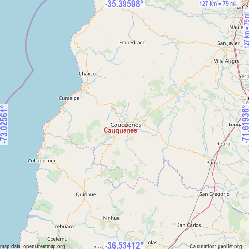
Cauquenes GPS coordinates[2]
35° 58' 1.56" South, 72° 19' 20.928" West
| Map corner | latitude | longitude |
|---|---|---|
| Upper-left | -35.39598°, | -73.02561° |
| Center: | -35.9671°, | -72.32248° |
| Lower-right: | -36.53412°, | -71.61936° |
| Map W x H: | 126.5×126.5 km | = 78.6×78.6mi |
| max Lat: | -18.19821° ⇑49.7% North |
| Cauquenes: | -35.9671° |
| min Lat: | ⇓50.3% South -54.93355° |
| min Long | Cauquenes | max Long |
| -109.42438° | -72.32248° | -67.60963° |
| W 40%⇐ | ⇒60% E |
Elevation
Elevation of Cauquenes is 172 m = 564 ft, and this is 101 m = 331 ft below average elevation for this country.
| Max E: |
3544 m = 11627 ft | 44.8% |
| Avg. | 273 m = 896 ft | |
| Cauquenes | 172 m = 564 ft | |
Min E: |
1 m = 3 ft | 55.2% |
See also: Chile elevation on elevation.city.
Geographical zone
Cauquenes is located in South temperate zone (between Tropic of Capricorn and the Antarctic Circle). Distance of this Southern Tropic circle is 1393.2 km =865.7 mi to North.| Distance of | km | miles | from Cauquenes |
|---|---|---|---|
| Equator | 3999.2 | 2485 | to North |
| Tropic Capricorn | 1393.2 | 865.7 | to North |
| Antarctic Circle | 3402 | 2113.9 | to South |
| South Pole | 6007.9 | 3733.1 | to South |


Nearby cities:
15 places around Cauquenes: (largest is in red/bold)
• Bulnes
86.2 km =53.6 mi,  178°
178°
• Chillán
73.8 km =45.9 mi,  164°
164°
• Coihueco
85.7 km =53.3 mi,  149°
149°
• Colbún
88 km =54.7 mi,  69°
69°
• Constitución
70.9 km =44.1 mi,  353°
353°
• Linares
67 km =41.6 mi,  78°
78°
• Longaví
57.5 km =35.7 mi,  89°
89°
• Parral
48.7 km =30.3 mi,  113°
113°
• Penco
105 km =65.2 mi,  215°
215°
• Quirihue
40 km =24.9 mi,  209°
209°
• San Carlos
60.5 km =37.6 mi, 147°
• San Clemente
89.2 km =55.4 mi,  57°
57°
• San Javier
67.6 km =42 mi,  52°
52°
• Talca
85.1 km =52.9 mi, 45°
• Tomé
91.9 km =57.1 mi, 218°
Sources, notices
• [Note1] Compared only with cities in Chile existing in our database
• [Src1] Map data: © OpenStreetMap contributors (CC-BY-SA)
• [Src2] Other city data from geonames.org with taken over terms of usage.
• [Src3] Geographical zone / Annual Mean Temperature by Robert A. Rohde @ Wikipedia
