Longaví geodata
Longaví (Maule Region) is a populated place; located in Chile in America/Santiago (GMT-4) time zone. With population of 6,325 people, there are 117 cities with bigger population in this country. Compared to other cities in Chile, 51% of cities are located further ↓South; 50.3% of cities are located further ←West and 53.8% of cities have lower elevation than Longaví. Note1


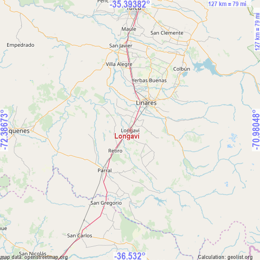
Longaví GPS coordinates[2]
35° 57' 53.856" South, 71° 41' 0.96" West
| Map corner | latitude | longitude |
|---|---|---|
| Upper-left | -35.39382°, | -72.38673° |
| Center: | -35.96496°, | -71.6836° |
| Lower-right: | -36.532°, | -70.98048° |
| Map W x H: | 126.6×126.6 km | = 78.7×78.7mi |
| max Lat: | -18.19821° ⇑49% North |
| Longaví: | -35.96496° |
| min Lat: | ⇓51% South -54.93355° |
| min Long | Longaví | max Long |
| -109.42438° | -71.6836° | -67.60963° |
| W 50.3%⇐ | ⇒49.7% E |
Elevation
Elevation of Longaví is 153 m = 502 ft, and this is 120 m = 394 ft below average elevation for this country.
| Max E: |
3544 m = 11627 ft | 46.2% |
| Avg. | 273 m = 896 ft | |
| Longaví | 153 m = 502 ft | |
Min E: |
1 m = 3 ft | 53.8% |
See also: Chile elevation on elevation.city.
Geographical zone
Longaví is located in South temperate zone (between Tropic of Capricorn and the Antarctic Circle). Distance of this Southern Tropic circle is 1393 km =865.6 mi to North.| Distance of | km | miles | from Longaví |
|---|---|---|---|
| Equator | 3998.9 | 2484.8 | to North |
| Tropic Capricorn | 1393 | 865.6 | to North |
| Antarctic Circle | 3402.2 | 2114 | to South |
| South Pole | 6008.1 | 3733.3 | to South |


Nearby cities:
15 places around Longaví: (largest is in red/bold)
• Bulnes
102.5 km =63.7 mi,  212°
212°
• Cauquenes
57.5 km =35.7 mi,  269°
269°
• Chillán
80.7 km =50.1 mi, 207°
• Coihueco
74.9 km =46.5 mi,  190°
190°
• Colbún
39.1 km =24.3 mi,  39°
39°
• Constitución
96.2 km =59.8 mi,  316°
316°
• Curicó
116.4 km =72.3 mi,  20°
20°
• Linares
15.5 km =9.6 mi,  31°
31°
• Molina
101.3 km =62.9 mi, 20°
• Parral
23.6 km =14.7 mi, 212°
• Quirihue
84.6 km =52.6 mi,  245°
245°
• San Carlos
56.7 km =35.2 mi, 205°
• San Clemente
50.7 km =31.5 mi, 20°
• San Javier
41.3 km =25.7 mi,  354°
354°
• Talca
59.9 km =37.2 mi,  2°
2°
Sources, notices
• [Note1] Compared only with cities in Chile existing in our database
• [Src1] Map data: © OpenStreetMap contributors (CC-BY-SA)
• [Src2] Other city data from geonames.org with taken over terms of usage.
• [Src3] Geographical zone / Annual Mean Temperature by Robert A. Rohde @ Wikipedia
