Dimako geodata
Dimako (East) is a populated place; located in Cameroon in Africa/Douala (GMT+1) time zone. With population of 8,476 people, there are 76 cities with bigger population in this country. Compared to other cities in Cameroon, 68.9% of cities are located further ↑North; 80.3% of cities are located further ←West and 53.3% of cities have lower elevation than Dimako. Note1


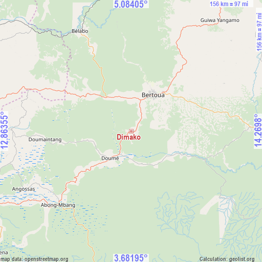
Dimako GPS coordinates[2]
4° 22' 59.988" North, 13° 34' 0.012" East
| Map corner | latitude | longitude |
|---|---|---|
| Upper-left | 5.08405°, | 12.86355° |
| Center: | 4.38333°, | 13.56667° |
| Lower-right: | 3.68195°, | 14.2698° |
| Map W x H: | 155.9×155.9 km | = 96.9×96.9mi |
| max Lat: | 12.57535° ⇑68.9% North |
| Dimako: | 4.38333° |
| min Lat: | ⇓31.1% South 2.35° |
| min Long | Dimako | max Long |
| 8.8724° | 13.56667° | 15.23288° |
| W 80.3%⇐ | ⇒19.7% E |
Elevation
Elevation of Dimako is 649 m = 2129 ft, and this is 24.9 m = 82 ft below average elevation for this country.
| Max E: |
1687 m = 5535 ft | 46.7% |
| Avg. | 673.9 m = 2211 ft | |
| Dimako | 649 m = 2129 ft | |
Min E: |
1 m = 3 ft | 53.3% |
See also: Cameroon elevation on elevation.city.
Geographical zone
Dimako is located in North Torrid zone (between Equator and Tropic of Cancer). Distance of Equator is 487.4 km =302.9 mi to South.| Distance of | km | miles | from Dimako |
|---|---|---|---|
| North Pole | 9519.7 | 5915.3 | to North |
| Arctic Circle | 6913.8 | 4296 | to North |
| Tropic Cancer | 2118.5 | 1316.4 | to North |
| Equator | 487.4 | 302.9 | to South |


Nearby cities:
15 places around Dimako: (largest is in red/bold)
• Abong Mbang
61.5 km =38.2 mi,  223°
223°
• Akonolinga
161.3 km =100.2 mi,  244°
244°
• Batouri
88.9 km =55.2 mi,  86°
86°
• Bertoua
25.2 km =15.7 mi,  31°
31°
• Bélabo
67.9 km =42.2 mi,  334°
334°
• Bétaré Oya
146.9 km =91.3 mi,  22°
22°
• Doumé
21.1 km =13.1 mi, 217°
• Essé
187.5 km =116.5 mi,  260°
260°
• Mbandjok
184.9 km =114.9 mi,  272°
272°
• Mbang
34.1 km =21.2 mi,  310°
310°
• Minta
87.8 km =54.6 mi,  284°
284°
• Nanga Eboko
137.1 km =85.2 mi, 284°
• Ndelele
155.4 km =96.6 mi,  104°
104°
• Nkoteng
170.6 km =106 mi, 274°
• Yoko
188.5 km =117.1 mi, 312°
Sources, notices
• [Note1] Compared only with cities in Cameroon existing in our database
• [Src1] Map data: © OpenStreetMap contributors (CC-BY-SA)
• [Src2] Other city data from geonames.org with taken over terms of usage.
• [Src3] Geographical zone / Annual Mean Temperature by Robert A. Rohde @ Wikipedia
