Batouri geodata
Batouri (East) is a populated place; located in Cameroon in Africa/Douala (GMT+1) time zone. With population of 43,821 people, there are 38 cities with bigger population in this country. Compared to other cities in Cameroon, 68% of cities are located further ↑North; 91% of cities are located further ←West and 50.8% of cities have lower elevation than Batouri. Note1


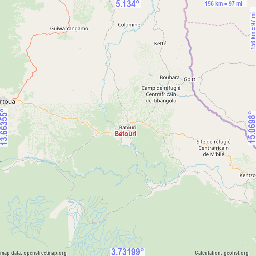
Batouri GPS coordinates[2]
4° 25' 59.988" North, 14° 22' 0.012" East
| Map corner | latitude | longitude |
|---|---|---|
| Upper-left | 5.134°, | 13.66355° |
| Center: | 4.43333°, | 14.36667° |
| Lower-right: | 3.73199°, | 15.0698° |
| Map W x H: | 155.9×155.9 km | = 96.9×96.9mi |
| max Lat: | 12.57535° ⇑68% North |
| Batouri: | 4.43333° |
| min Lat: | ⇓32% South 2.35° |
| min Long | Batouri | max Long |
| 8.8724° | 14.36667° | 15.23288° |
| W 91%⇐ | ⇒9% E |
Elevation
Elevation of Batouri is 631 m = 2070 ft, and this is 42.9 m = 141 ft below average elevation for this country.
| Max E: |
1687 m = 5535 ft | 49.2% |
| Avg. | 673.9 m = 2211 ft | |
| Batouri | 631 m = 2070 ft | |
Min E: |
1 m = 3 ft | 50.8% |
See also: Batouri elevation on elevation.city.
Geographical zone
Batouri is located in North Torrid zone (between Equator and Tropic of Cancer). Distance of Equator is 492.9 km =306.3 mi to South.| Distance of | km | miles | from Batouri |
|---|---|---|---|
| North Pole | 9514.1 | 5911.8 | to North |
| Arctic Circle | 6908.2 | 4292.6 | to North |
| Tropic Cancer | 2113 | 1313 | to North |
| Equator | 492.9 | 306.3 | to South |


Nearby cities:
15 places around Batouri: (largest is in red/bold)
• Abong Mbang
140.4 km =87.2 mi,  249°
249°
• Akonolinga
246.2 km =153 mi, 252°
• Bertoua
77.3 km =48 mi,  281°
281°
• Bélabo
130.6 km =81.2 mi,  295°
295°
• Bétaré Oya
133.5 km =83 mi,  346°
346°
• Dimako
88.9 km =55.2 mi,  266°
266°
• Doumé
104 km =64.6 mi,  257°
257°
• Garoua Boulaï
162.5 km =101 mi,  7°
7°
• Mbang
115.7 km =71.9 mi, 278°
• Meïganga
231.8 km =144 mi,  358°
358°
• Minta
174.5 km =108.4 mi, 275°
• Nanga Eboko
223.4 km =138.8 mi, 277°
• Ndelele
75.8 km =47.1 mi,  125°
125°
• Yokadouma
127 km =78.9 mi,  143°
143°
• Yoko
257.9 km =160.3 mi, 298°
Sources, notices
• [Note1] Compared only with cities in Cameroon existing in our database
• [Src1] Map data: © OpenStreetMap contributors (CC-BY-SA)
• [Src2] Other city data from geonames.org with taken over terms of usage.
• [Src3] Geographical zone / Annual Mean Temperature by Robert A. Rohde @ Wikipedia
